Alvaro Sanchez, Chief Executive Office.
We remain deeply committed to Ukraine, enhancing the safety and security of their warfighters and platforms. The invaluable feedback from warfighters has enabled us to advance our offensive and defensive electronic warfare (EW) technologies. These systems now offer lighter, more power-efficient, and highly effective solutions to combat emerging multidomain threats, including sophisticated jamming and anti-jamming capabilities.

In the defense sector, we have forged strong partnerships with customers and other contractors, achieving notable milestones. We joined a Next-Gen Fighter Aircraft consortium, securing multiple projects in this cutting-edge domain. Additionally, we were awarded a prime contractor role to develop the EU Satellite Jammer technology, designed for training purposes or the temporary denial of selected services. Our advancements in Earth Observation (EO) now include the use of optical and SAR imaging to identify and characterize military objects from space.
 We also secured government projects focused on Digital Twins of the Enterprise, enhancing operational modeling and simulation, and contributed to the secure connectivity of the IRIS2 European Union (EU) multi-orbit satellite constellation, reinforcing European space capabilities.
Furthermore, we initiated the delivery of Quantum Key Distribution (QKD) solutions via satellite, providing next-generation, secure, communication technologies. These achievements highlight our commitment to innovation in defense and multidomain operations.
Our four new products address issues faced by both the commercial and government operators.
LEO NMS
Satellite networks have undergone significant changes over the past few years, largely driven by the rise of large Low Earth Orbit (LEO) constellations.
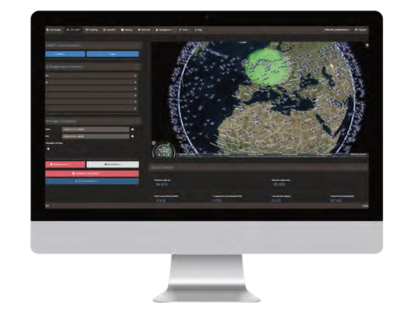 Each link is optimized for individual customers and tailored to diverse scenarios, with flexibility to meet any requirement. Automatically generated reports document the reasons behind the chosen path, ensuring transparency.
 Starlink, with its thousands of satellites supporting diverse applications and markets, has revolutionized the industry. OneWeb, a smaller LEO constellation, has also made strides, and the landscape will soon include Kuiper, Telesat Lightspeed (recently funded), and the IRIS2 Spacerise consortium (Eutelsat, Hispasat, and SES), with others likely to follow.
To address these complexities, we developed the LEO Network Management System (NMS). This solution was inspired by customer feedback regarding the challenges of integrating numerous Starlink satellites with traditional network infrastructures. While Starlink served as the inspiration, LEO NMS is orbit- and provider-agnostic, capable of managing multi-orbit, multi-vendor, and multi-frequency networks within a single orchestration platform.
As a result, many modern networks now consist of bandwidth (Mbps) sourced from thousands of satellites across multiple orbits, owned by different operators and utilizing various frequencies. This marks a significant shift from just a few years ago when networks were often limited to bandwidth from a handful of geostationary (GEO) satellites and, in some cases, O3b’s Medium Earth Orbit (MEO) constellation.
To address these complexities, we developed the LEO Network Management System (NMS). This solution was inspired by customer feedback regarding the challenges of integrating numerous Starlink satellites with traditional network infrastructures. While Starlink served as the inspiration, LEO NMS is orbit- and provider-agnostic, capable of managing multi-orbit, multi-vendor, and multi-frequency networks within a single orchestration platform.
LEO NMS provides comprehensive network control, enabling users to monitor performance at all levels—from individual terminals to entire networks of thousands of terminals. Its intuitive, web-based interface simplifies orchestration, maintenance, and optimization of multi-orbit and multi-frequency satellite networks.
The system includes tools to automate and manage up/down speeds, quality of service (QoS), service level agreements (SLAs), time-to-resolution metrics, payment and invoicing, and even contract brokering and cross-sales. All features are accessible via a fully redundant public or private cloud.
Additionally, LEO NMS includes a DoD/MoD portal (such as a Virtual Network Operator, or VNO), allowing operators or service providers to offer their customers secure, filtered access to monitor and manage their own networks. This ensures flexibility, security, and functionality for both commercial and defense users.
BestPath
With the exponential growth in satellites driven by LEO constellations and the rapid expansion of multi-orbit options, selecting the optimal connectivity path has become a complex challenge. To address this, we developed BestPath, a groundbreaking technology built on our EM&C system to ensure reliable connectivity.
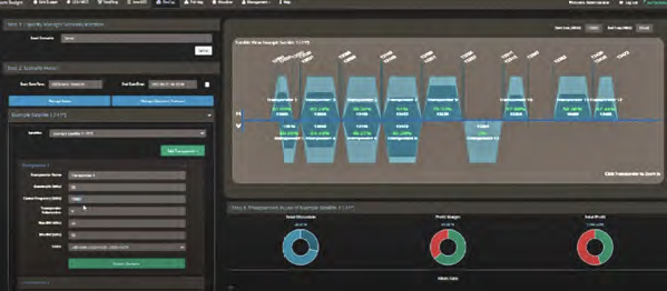
BestPath enables users or systems to effortlessly evaluate multiple link budgets, options, and scenarios for purchasing or connecting. It simplifies and automates network selection, purchasing, design, and orchestration while providing backup capabilities and executing decisions in real time.
The ideal connectivity path is identified in less than one second, based on pre-set criteria and real-time inputs specified by the user, such as QoS, SLAs, satellites, antennas, beams, latency, power, bandwidth, and cost.
Each link is optimized for individual customers and tailored to diverse scenarios, with flexibility to meet any requirement. Automatically generated reports document the reasons behind the chosen path, ensuring transparency.
 Each link is optimized for individual customers and tailored to diverse scenarios, with flexibility to meet any requirement. Automatically generated reports document the reasons behind the chosen path, ensuring transparency.
BestPath is invaluable for selecting both primary and backup links, whether due to service disruptions caused by adverse events, electromagnetic interference (EMI), power outages, cyberattacks, or the movement of ships, planes, or vehicles.
It is particularly effective in military applications, where electronic warfare (EW) systems and dynamic environments demand rapid and adaptive connectivity.
BestPath seamlessly integrates with FlexCap for capacity management and resource orchestration, and its APIs enable smooth integration into other systems to automatically adjust bandwidth as needed.
Accessible via a web-based platform, it offers users the convenience of managing connectivity from anywhere.
Orbisat
LEO constellations bring not only expanded bandwidth and connectivity options but also unprecedented congestion. Space is now more crowded than ever, with congestion increasing daily as new satellites are launched and mission failures generate additional debris.
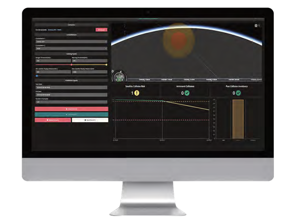
Orbisat isn’t just an SDA/SST solution, it’s a comprehensive system of systems designed to automate the protection of space infrastructure. In an era where a single major collision could have devastating consequences, Orbisat ensures proactive and reliable space safety measures.
Recognizing space as a contested operational domain, the U.S. Space Force has emphasized the urgency for updated Space Domain Awareness (SDA) and Space Surveillance and Tracking (SST) systems. In response to this pressing need, we developed Orbisat.
Orbisat, pictured above, is an API-driven solution designed for seamless integration with radars, telescopes, optical sensors, classified systems, and onboard GPS to enhance surveillance accuracy. It integrates with proprietary and public subsystems to enable tracking, collision avoidance, telemetry, maneuverability detection, Telecommand & Control, and the identification of undocumented objects in all orbits, including deep space.
The system connects to public databases such as Celestrack and Spacetrack and continuously updates using integrated antennas that monitor and measures S-band links during orbit and the launch and early orbit phase (LEOP). Its advanced monitoring capabilities detect unidentified objects under the noise floor with minimal data, ensuring comprehensive coverage of all threats.
In potential collision scenarios, Orbisat works with TT&C to automate maneuvers, avoiding risks efficiently. It also analyzes foreign object behavior to assess potential threats, taking space situational awareness a step further.
Orbisat isn’t just an SDA/SST solution, it’s a comprehensive system of systems designed to automate the protection of space infrastructure. In an era where a single major collision could have devastating consequences, Orbisat ensures proactive and reliable space safety measures.
EO Master
In the extremely time-sensitive world of geospatial intelligence (GEOINT), timely identification of objects is crucial. EO Master integrates artificial intelligence (AI) and machine learning (ML) into image processing to enable image characterization within milliseconds of it being downloaded.
EO Master is integrated with AI/ML libraries and algorithms for vast real-time analysis. The image is compared with millions of 3D models on file and a huge amount of synthetic data trained. For defense application, it can incorporate the latest global military platforms for precise comparisons.
Currently, EO is provided by both optical and synthetic radar (SAR) systems, but the tools to use each of these are proprietary, on many occasions with not sufficient certainty and precision. EO Master is the first system to utilize both options for object characterization. The user interface is an easy-to-use graphical user interface (GUI), allowing government and other users without deep technical knowledge to identify the immediate impact of natural disasters, identify traffic and population patterns, and for defense applications compare real vs fake objects.
GEOINT has many uses. It is a powerful tool for environmental monitoring, video resolution is so high now, that even changing leaf patterns can be identified.
For the military, GEOINT is literally “the eyes in the sky,” indicating troop buildup and movement, as well as identifying armaments on the ground or illegal fishing, trafficking or immigration.

Our Success
This has been exceptional and we credit much of our success to close communication with customers. They may buy a product, but they get a trust relationship. We’re there when needed, listening to their requirements to develop products meeting the latest warfighter needs.
Our success is evident not only through long-standing customer relationships but also through the numerous technology awards we’ve won, including the MSUA Satellite Innovation of the Year award for three consecutive years, thanks to our dedicated team of engineers committed to innovation for the warfighter’s benefit.
www.integrasys-space.com
About the author
 Álvaro Sánchez, Marquis of Antella and CEO of Integrasys, is a software and industrial engineer, with a Master’s Degree in Business from ESIC Business School (Spain). He has worked at Integrasys since 2011, initially in engineering then management and sales executive roles where he was successful in growing both revenue and profit, before becoming CEO in 2018. In 2021, Sr. Sánchez took on the role of Professor, teaching “Introduction to Business Management” for the AI degree at the IE University (Madrid), thus achieving his goal of helping others. In 2021, he was named by SSPI as one of the 20 under 35 Space Professionals. His current focus is on growing Integrasys, developing new products, forging alliances with other defense and commercial organizations if appropriate, as well as partnering with MoDs and DoDs. In addition, he is also focused on geographical expansion with the opening of two new offices, one in London and one in Ukraine, during the last 18 months.

