
Dr. Kateryna Sergieieva, Scientist, EOS Data Analytics
While volcanic eruptions can be unpredictable and devastating, modern technology is changing how we monitor these fiery giants. Satellites, orbiting high above Earth, provide an unprecedented view of volcanic activity, capturing critical data that can help scientists track warning signs, assess hazards, and even prevent disasters before they unfold.

By detecting changes in temperature, gas emissions, and ground deformation, satellite data offers a broader, more continuous perspective than traditional ground-based monitoring. With a live satellite view of your AOI, as a researcher you can observe volcanic activity in near real-time, making it easier to identify early warning signs and assess risks.
This level of remote monitoring enables timely evacuation plans, reduces damage to infrastructure, and ultimately saves lives. As climate change influences global volcanic activity, the role of space- based observation is becoming even more vital. The ability to predict eruptions and act swiftly in response is no longer some sort of faraway dream but one made real through ever-advancing satellite capabilities
________________________________________________________
Satellite data and its role in volcanic eruptions
________________________________________________________
Predicting volcanic eruptions has always been one of the greatest challenges in geoscience. While some warning signs, such as tremors, gas emissions, and ground swelling, can be detected through ground sensors, these methods are often limited by accessibility, harsh environments, and the unpredictable nature of volcanic behavior. This is where satellite technology transforms the field, offering a more comprehensive, real-time approach to volcanic monitoring.
Live satellite view of Earth allows scientists to monitor changes across vast, remote regions that would otherwise be difficult or impossible to access. Unlike ground-based systems, which are often placed near a volcano’s crater, satellites capture a broader perspective, detecting even the most subtle shifts in a volcano’s activity. Through thermal imaging, satellites can track rising magma beneath the surface, while specialized sensors measure gas emissions like sulfur dioxide—key indicators of an impending eruption.
One of the greatest advantages of satellite monitoring is its ability to provide continuous, large-scale surveillance. Many active volcanoes are in remote or dangerous locations where installing ground instruments is not feasible. With satellite data, researchers can analyze long-term trends in volcanic behavior, compare current activity with historical patterns, and issue alerts when signs of an eruption become evident. This proactive approach gives local authorities and disaster response teams critical time to prepare, evacuate communities, and minimize destruction.
Satellites also help mitigate the impact of false alarms. Not every tremor or plume of gas signals an eruption, and the reliance on ground data sometimes brings about unnecessary evacuations. Satellite observations, put together with seismic and geological data, enable scientists to distinguish normal volcanic activity from truly dangerous events, ensuring that warnings are timely and accurate.
As technology advances, the capabilities of satellite-based volcanic monitoring continue to improve. High-resolution imagery, real-time analytics, and AI-powered models are making eruption predictions more precise than ever. With the ability to monitor volcanic activity
on a global scale, satellites are changing not just how we predict eruptions but also how we protect lives, infrastructure, and even whole ecosystems from nature’s most unpredictable disasters.
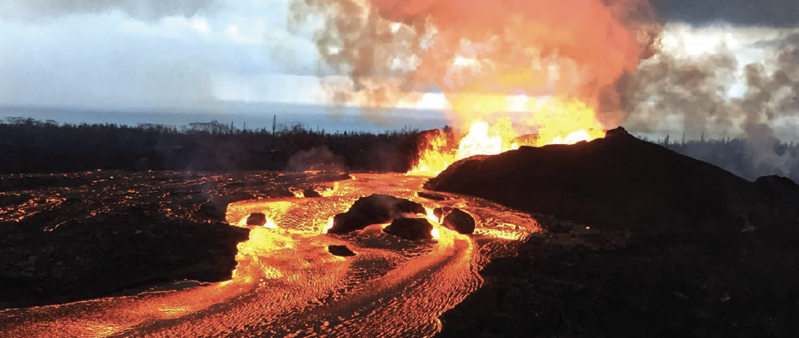
Kilaeua volcano in Hawaii
_____________________________________________________________________________
Underwater eruptions and their detection using satellite imagery
_____________________________________________________________________________
Unlike their land-based counterparts, underwater volcanoes erupt in near silence, hidden beneath vast ocean depths. Without visible lava flows or towering ash plumes, these eruptions often go unnoticed until their aftermath is detected on the ocean’s surface. However, satellites are changing that. By capturing real-time data from above, they provide a powerful tool for detecting and analyzing these hidden geological events, offering insights that were once beyond our reach.
 A live stream satellite view of Earth’s oceans allows scientists to identify subtle but telling signs of an underwater eruption. One of the most crucial indicators is the sudden discoloration of seawater caused by volcanic gases and minerals being released into the ocean. Sulfur, iron, and other elements create swirling patches of yellow, green, or brown on the water’s surface—signals that something is stirring in the deep. Satellites also track surface temperature anomalies.
While the deep ocean is cold, an erupting submarine volcano releases immense heat, sometimes warming the surrounding water by several degrees. Infrared sensors aboard satellites can detect these thermal changes, helping scientists pinpoint where an eruption is occurring, even in the most remote areas of the ocean.
Another key advantage of satellite monitoring is its ability to detect pressure waves from explosive underwater eruptions. When a massive eruption occurs, it can trigger shockwaves that ripple through the atmosphere. By analyzing these disturbances, researchers can not only confirm an eruption but also estimate its intensity and potential impact.
Beyond detection, satellite data plays a critical role in predicting the effects of underwater eruptions. Tsunamis, for example, are a major threat following submarine volcanic activity. By monitoring changes in sea level and ocean currents from space, satellites help provide early warnings, giving coastal communities valuable time to prepare and evacuate if necessary.
As satellite technology continues to evolve, so does our ability to monitor the hidden world beneath the ocean’s surface. With improved resolution, real-time data processing, and AI-driven analysis, scientists are gaining an unprecedented understanding of underwater volcanic activity. What was once an unseen force of nature is now being revealed one satellite image at a time.
_______________________________________
Volcanoes Observed from Space
_______________________________________
From the fiery summits of the Andes to the hidden depths of the Pacific, satellites have provided critical insights into some of the world’s most active and dangerous volcanoes.
One of the most striking examples is Mount Etna in Italy, Europe’s most active volcano, where satellites routinely track its frequent eruptions and lava flows.
In the Pacific, the Hunga Tonga-Hunga Ha’apai eruption in 2022 was one of the most powerful underwater eruptions ever recorded. Satellite imagery captured the massive ash cloud that reached the stratosphere and the pressure waves that circled the planet multiple times.
Meanwhile, in Indonesia, Mount Merapi, one of the most hazardous volcanoes on Earth, has been closely monitored using satellite data to detect changes in gas emissions and surface deformation, helping to issue timely evacuation warnings.
Even remote volcanoes, like Kilauea in Hawaii and Nyiragongo in the Democratic Republic of Congo, are observed from space, providing invaluable data on lava lake activity and ground instability.
Whether towering above cities or hidden beneath the sea, these restless giants are under constant watch, proving that no volcano, no matter how remote, is beyond our reach.
________________________
Look Into the Future
________________________
As technology advances, the way we monitor volcanoes from space is evolving at an unprecedented pace. Today, satellites equipped with thermal imaging, gas sensors, and radar can track volcanic activity in near real-time.
But the future holds even greater promise. The integration of AI and machine learning is transforming how we analyze satellite data, making eruption predictions faster and more accurate than ever before.
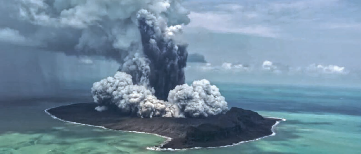
Hunga Tonga-Hunga Ha’apai eruption in 2022
With real-time satellite view, scientists will soon be able to detect even the most subtle signs of volcanic unrest before they escalate into full-scale eruptions.
AI-driven algorithms will automatically scan massive amounts of satellite data, identifying patterns that might go unnoticed by human analysts. This will allow for earlier and more precise warnings, giving people more time to evacuate and prepare for potential disasters.

New satellite missions, such as hyperspectral imaging systems, will also improve our ability to monitor volcanic gas emissions, while advanced radar technology will track ground deformation with millimeter precision.
These innovations will be particularly crucial for monitoring remote or underwater volcanoes, where traditional observation methods fall short.

Kateryna
Sergieieva
In the coming years, satellites will not only help predict eruptions but also assess their impact in real time. High-resolution satellite live view of Earth will assist in disaster response, guiding emergency teams to the most affected areas and helping communities rebuild faster.
eos.com
Author Kateryna Sergieieva has a Ph.D. in information technologies and 15 years of experience in remote sensing. She is a scientist responsible for developing technologies for satellite monitoring and surface feature change detection. Kateryna is an author of more than 60 scientific publications.