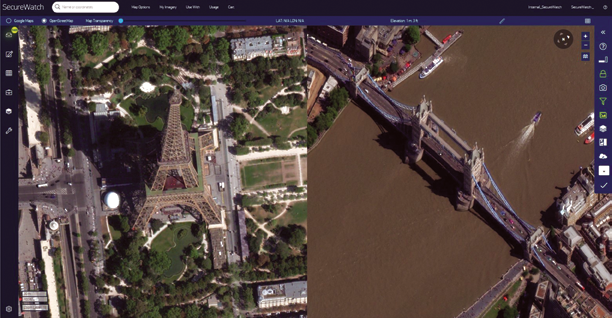
 Figure 1. Satellite image captures of Paris and London by Maxar’s WorldView-3 satellite.
In the two years since releasing the SecureWatch product, Maxar’s subscription-based Earth intelligence product, the company has learned a great deal about how to serve customers who focus on national security.

The firm’s product managers have spent hundreds of hours demonstrating our product to customers and training dozens of defense and intelligence agencies around the world. In that process, we gained a deeper understanding of customers’ geospatial intelligence (GEOINT) missions and how those requirements can be met to ensure mission success. It boils down to the fact that defense customers primarily focus on two GEOINT missions:
Collection and maintenance of foundational intelligence (Figure 2)
Most defense and intelligence agencies are responsible for producing foundational GEOINT across broad areas by cataloging natural and human-made features such as terrain, lines of communication, civil and military facilities and critical infrastructure. This mission enables agencies to publish maps, manage GIS databases and to develop a holistic understanding of civil and military capabilities for the purposes of advising policy makers and planning and executing security missions.
Event and location-specific intelligence gathering (Figure 3)
Defense and intelligence agencies also study the geospatial context of event- and location-specific activities such military deployments and natural and human-made disasters. This mission enables agencies to develop an understanding of activity at key facilities and active events, which is accurate to the day, hour or even minute.
Mission Requirements
These two GEOINT missions have a complicated set of overlapping and occasionally conflicting requirements for a provider of geospatial intelligence. Our ability to balance requirements across both missions for a variety of customers is what ultimately delivers valuable products aiding the success of all of our customers’ missions.
Common Requirements
Foundational GEOINT and focused intelligence collection both require imagery from the overhead perspective. Since World War I, overhead imagery is what has provided an authoritative source of GEOINT and enabled data collection over small and large areas. For both broad and focused missions, overhead imagery must:
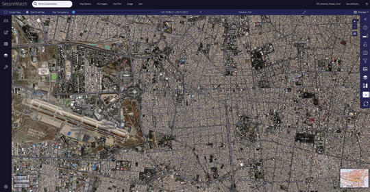 Figure 2. Example of broad area, foundational GEOINT collection in
Tehran, Iran using SecureWatch with a streaming Vivid imagery mosaic. 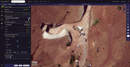 Figure 3. Example of location specific intelligence collection at a military site in Iran using SecureWatch Image Exploitation Mode. This is a WorldView-3 image from August 14, 2019.
• Enable clear visibility to the ground. Satellite imagery can be collected for any piece of the globe. However, cloud-free imagery is challenging to collect, especially in tropical areas. This requirement is best met using a combination of electro-optical (EO) and synthetic aperture RADAR (SAR) assets in order to deliver the all-weather flexibility of SAR with EO imagery’s ability to clearly identify and classify objects.
• Provide sufficient resolution to distinguish features of interest on the ground. Both GEOINT missions typically require imagery with 50 cm ground sample distance or better to confidently identify objects and activities of interest such as military equipment and posture.
• Deliver reliable accuracy for geographic feature collection and interoperability between multiple data sets. Images must be collected and processed in a manner that enables the geospatially accurate collection of features in all areas of the world.
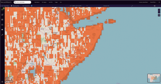 Figure 4. The orange strips represent Maxar optical satellite images added to SecureWatch within the last year that cover the populated areas in Somalia. This allows an analyst to create an accurate foundational GEOINT report on a topic such as critical infrastructure.
Unique Requirements
Foundational GEOINT and focused intelligence also present unique requirements that must be balanced when considering how data is collected, processed and delivered. Consider the following:
Imagery Refresh Cycle (Figure 4)
Foundational GEOINT collection requires relatively recent imagery over large areas. This enables analysts to create up-to-date maps and databases. For example, to create an accurate database of all critical infrastructure in Somalia, analysts could require imagery collected within the last 12 months covering all populated areas of the country.
 Maxar EO (Figure 5a, this page) and SAR (Figure 5b, next page) satellite images of the port at Mogadishu displayed in SecureWatch, which enable analysts to monitor activity regardless of weather and light conditions.
 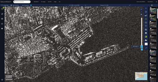 Figure 5b.
Focused intelligence (Figures 5a and Figure 5b) requires imagery which is updated frequently over small areas, regardless of weather and light conditions. An example mission could require new imagery of the port at Mogadishu, Somalia, as frequently as possible to report accurately on activity.
Image Processing (Figures 6a and 6b)
To cover broad areas, foundational GEOINT missions require multiple images to be processed to remove inconsistencies between each image, like the removing of clouds, resampling to consistent image resolution, compensating for atmospheric effects and balancing light conditions. The process of blending multiple images enables both human and machine-based extraction to operate most efficiently over large areas.
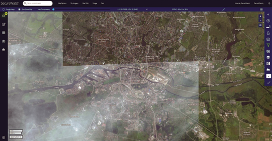 Figure 6a. This SecureWatch screenshot shows a mash-up of several unbalanced images layered over Kaliningrad. On the next page, Figure 6b displays the images after being blended and balanced to create a single imagery mosaic, enabling machine-based and human feature extraction to operate most accurately and efficiently.
 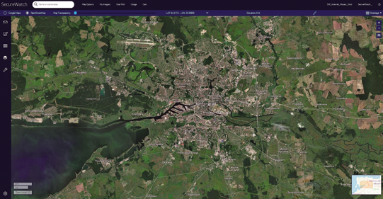 Figure 6b.
Focused intelligence collection (Figure 7) requires images that are as high-resolution as natively possible to minimize artifacts that might result in false positive or negative detections. In addition, images that are unfit for mosaic production due to atmospheric conditions or collection geometry may be highly valuable for studying a specific area.
Meeting the Mission Requirements
Addressing these overlapping and conflicting requirements is a challenge. For a product team, this challenge presents opportunity: we aim to understand these requirements and develop productized capabilities at Maxar to address them. Here are some examples:
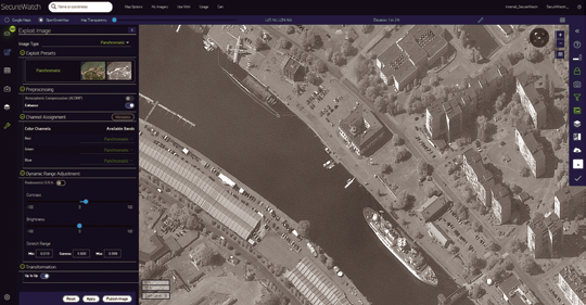 Figure 7. This recent WorldView-1 image of Kaliningrad was not used for mosaic production because it is panchromatic (black and white) and was collected at a high off-nadir angle. This image is still very valuable for an analyst studying facilities this area and is available in SecureWatch both online and with Image Exploitation Mode.
 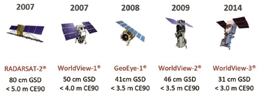 Figure 8.
The Maxar Constellation (Figure 8)
Maxar owns and operates the world’s most advanced constellation of commercial EO and SAR satellites, which collect both wide area and focused data. The active, five-satellite constellation images with the highest accuracy and resolution available commercially, as well as images in all weather and light conditions. A global network of downlink facilities and backhaul connections supports the constellation by delivering new images to our production facility within minutes of collection.
Production and hosting of “The Daily Take” (Figure 9)
Maxar produces an average of 1.5 million square kilometers of new EO and SAR imagery every day, within strict time and accuracy requirements for focused GEOINT collection. Missions requiring the latest imagery to monitor active facilities and activities on the ground are served with the latest imagery.
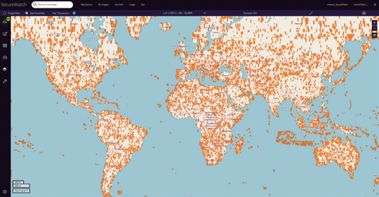 Figure 9. This graphic shows 30 days of Maxar’s “Global Daily Take” EO images represented by orange polygons.
 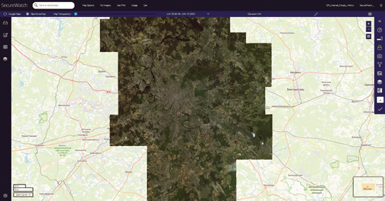 Figure 10 shows a single Metro imagery mosaic covering all of the Moscow metropolitan area with balanced, 30 cm resolution pixels.
Production and hosting of global imagery mosaics (Figure 10)
Maxar’s global mosaic products, Vivid and Metro, provide the world’s best imagery source for extracting geographic features by blending and balancing images from across our constellation. These wide-area images are ideal for both humans and machines to digitize features for foundational GEOINT.
On-demand archive access (Figure 11)
SecureWatch subscribers can access any non-private collection from Maxar’s 20-year imagery library to download images that are processed in the ideal manner for their mission. For example, customers desiring map-ready images can order fully processed, ortho-rectified images. Customers desiring images with minimal distortion can order nearly raw images.
Online image exploitation (Figure 12)
The latest version of SecureWatch enables customers to extract the full power of multi-spectral pixels instantaneously in the online interface, without the need for additional software, image processing or download. These new capabilities give users control over displayed spectral bands, advanced processing like atmospheric compensation (ACOMP) and dynamic range adjustment (DRA).
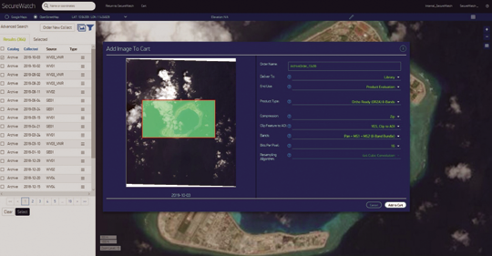 Figure 11. On-demand archive ordering in SecureWatch enables subscribers to order any of the 364 images of Subi Reef, dating from February 13, 2000 to October 3, 2019.
 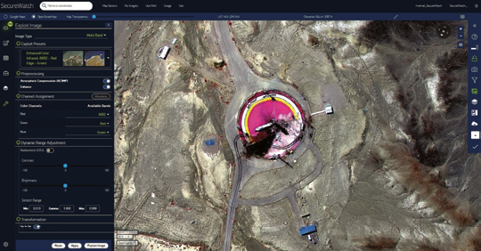 Figure 12. Image Exploitation Mode in SecureWatch enables a user to perform multi-spectral analysis of a failed missile launch at Semnan Space Facility in Iran within the web browser. This is an August 31, 2019 WorldView-3 image displayed as a near infrared color composite, which makes the launch pad appear hot pink (instead of blue as the human eye sees it) and better reveals the explosion mark.
Conclusion
Advancements in imaging technology and cloud computing will continue to enable Maxar to better serve both foundational GEOINT missions and focused intelligence collection. As a result, customers can expect their required capabilities across Maxar and within SecureWatch to continue to grow — Maxar is particularly excited about growing the firm’s ability to serve foundational GEOINT missions through a “living global mosaic,” which will be continuously updated with the latest clear imagery. The company continues to improve all abilities to serve focused intelligence collection with increased imagery refresh intervals over active sites with the upcoming WorldView Legion constellation.
Contact the company to request a free, 30 day, SecureWatch evaluation.