Return to the year 2008, when Michael Phelps swam into the history books with an astonishing finish to win his seventh gold medal by one one-hundredth of a second against Milorad Cavic.
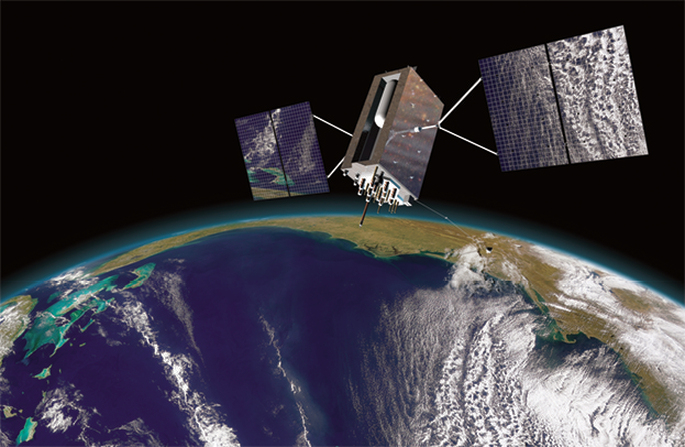
GPS III artistic rendition courtesy of Lockheed Martin.
By any stretch of the imagination, the time differential in this historic race was imperceptible, but for the Global Positioning System (GPS) an error of one one-hundredth of a second would be a disaster.1 Why?
For the GPS, one nanosecond (0.000000001 second) would result in the equivalent of approximately a one-foot error on Earth. Translated, Phelps’s razor-thin margin of victory would have produced an incredible error of almost 10,000,000 feet or approximately 1,894 miles. Although the GPS provides so much more than just timing accuracy, this measurand has become one of its key hallmarks, as have its space superiority and force-multiplying capabilities.
Joint Publication 3-14, Space Operations, defines “space superiority,” a primary focus of this article, as “the degree of dominance in space of one force over any others that permits the conduct of operations at a given time and place without prohibitive interference from space-based threats” (emphasis added).2 Although not yet fully operational at the time, the GPS was first used for combat in Operation Desert Storm, often called “the first space war.”3
From initial air strikes by Pave Low helicopters to General Norman Schwarzkopf’s famous “left hook,” the GPS served as a key force enabler, even with a very limited deployment of receivers.4 Furthermore, the GPS has been a crown jewel of the American military’s superior space capabilities for decades, through Operation Enduring Freedom. Yet, emerging threats and increasingly sophisticated foreign capabilities present new challenges to maintaining US technical and operational advantages.
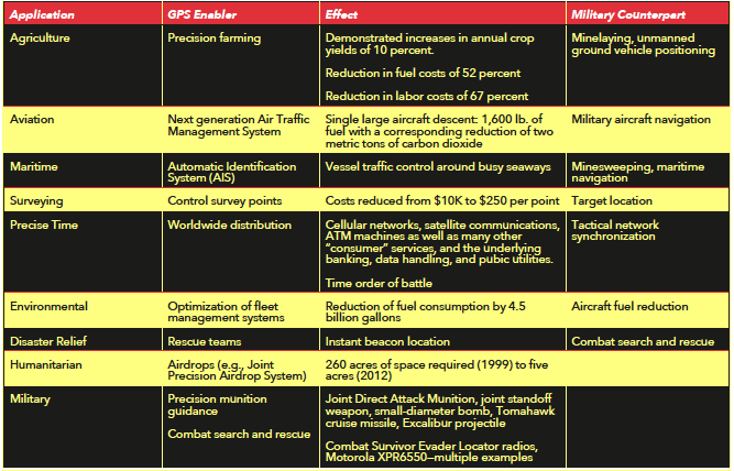
Provided free of charge by the US Air Force and acquired and operated by Air Force Space Command, the GPS is a critical national asset. A tangible symbol of US economic and military might and a system unmatched in performance, cost, and availability, the GPS is now used by well over 1 billion people and has been integrated into more than 2 billion devices, both commercial and military.5 Its applications are wide ranging and diverse, from aircraft navigation to network synchronization (see the table on the following page).
Although the law guarantees availability of the GPS to users worldwide, the system also serves as a critical fiber in our nation’s defense, clearly enabling space superiority as defined by Department of Defense (DoD) policy.
This article highlights how the GPS has become an integral part of our nation’s war-fighting and commercial capabilities, why it will remain essential to both national economic power and US military superiority, and how it will get better in the future. The article offers unique analogies, examples, and the firsthand experiences of two senior leaders of the GPS Directorate who have worked GPS strategy, policy, technology, and acquisition for more than 20 years combined.
The Importance Of The Global Positioning System
Positioning, navigation, and timing (PNT), a term rarely heard outside the US government, usefully consolidates under a single banner the various systems, policies, and activities concerned with providing critical positioning information, navigation capabilities, and time dissemination. By most measures, PNT is a thriving, healthy, global enterprise, largely due to the ubiquity of the GPS, which the United States has offered as a free global utility since the inception of the GPS program office in 1973.
Today, more than 3.3 million jobs rely on GPS technology, including approximately 130,000 in GPS manufacturing industries and 3.2 million in the downstream commercial, GPS-intensive industries. In light of high financial returns, we expect the commercial GPS adoption rate to continue to grow across industries. Consequently, the system’s technology will create $122.4 billion in benefits per year and will directly affect more than 5.8 million jobs in downstream commercial, GPS-intensive industries when penetration of the system’s technology reaches 100 percent in those industries.6
The GPS has proven brilliantly successful and so universally adopted that Russia, the European Union, and China have all developed imitations and are in various stages of deploying them. Additionally, more than 50 nations have developed GPS augmentations. In many ways, the GPS was the first truly global utility—one that is only now realizing its potential as new commercial applications emerge every year. The system has also become a symbol of military interoperability, boasting agreements with 55 US allies as authorized users of the military’s precise positioning service.
The GPS largely owes its success to the fact that no other system or technology can match its performance, cost, and availability. Traditional radio navigation aids are far less accurate and do not provide global coverage. Inertial systems are capable of very precise short-term accuracy, but physics dictates that their accuracy will diminish over time unless synchronized periodically with the GPS or a similar system. Atomic clocks keep accurate time but are costly, requiring significant power and thermal control.
Promising new technologies such as Chip-Scale Atomic Clocks, Cold Atom Inertial Systems, and Wi-Fi Navigation all reduce dependencies on the GPS alone; however, they probably will not deliver similar accuracy and pervasive availability for the foreseeable future. Instead, these technologies work best when integrated with other sensors—especially the GPS. As such, the US military continues to rely on the GPS, even as new technologies are integrated into weapon systems.7
Background
Like cell phones, computers, and the Internet, the GPS is used worldwide by ordinary citizens and the military forces of both allies and adversaries. Since the launch of its first satellite more than 30 years ago, the system has transformed navigation and precise timing. From the first GPS satellite launch on 22 February 1978, any user—military or civilian—could access the unencrypted coarse/acquisition (C/A) code on the primary GPS frequency L1 (1575.42 megahertz [MHz]).
From the system’s inception, military leaders have been concerned about universal access to the precise PNT offered by the GPS to friend and foe alike; thus, its “dual-use” phenomenology has, at times, caused friction between the military and civil user communities. As the commercial use of and reliance on the GPS increased, the effects of the “selective availability” methodology—the original means of limiting universal capability—proved too hard to bear for the US government.
The concept behind selective availability involved the employment of positioning and timing accuracy as a discriminator between military and civil users. The signal was intentionally degraded to 100-meter accuracy, a condition that authorized users with a valid decryption key could remove.
This practice not only was enormously unpopular with the civil GPS community but also was eventually circumvented by differential techniques. In fact, the Department of Transportation funded and developed differential GPS, leading to the untenable situation in which one arm of the federal government undermined another.
The downing of Korean Airlines Flight 007 by an aircraft of the former Soviet Union over the Sea of Japan on 1 September 1983 emphasized the critical need for a global civil-navigation system. A series of US policy initiatives promoting adoption of the GPS by civilian and commercial users followed, including Presidential Decision Directive no. 6 in March 1996, and culminated with the elimination of selective availability in May 2000.8 Its removal offered civilian GPS users the reliable accuracy previously delivered only to the US military and spawned explosive growth in the development of high-precision civilian applications in such fields as surveying, agriculture, and earth science.
On 27 September 2007, the White House announced that selective availability would no longer be included in future procurements of GPS satellites. Today, there is little difference in the accuracy available to US forces, civil users, or adversaries.
The Air Force took the additional step of committing to specific levels of civilian performance and backed up that commitment with US law. The GPS Standard Positioning System Performance Standard (SPS PS), first published in 1993, established minimum levels of GPS service in terms of constellation coverage, signal accuracy, and integrity for C/A code users. These GPS performance commitments—particularly important for safety-of-life applications—have allowed certification of the system for commercial aviation by both the Federal Aviation Administration and the International Civil Aviation Organization.
The SPS PS has been updated multiple times over the years, most recently in 2008, and will continue to undergo updates to account for the deployment of new civil signals. The US government’s commitment to GPS standards for civilian users has allowed receiver manufacturers and other commercial developers to commit resources to developing products and services based upon accurate, reliable, and globally available GPS signals. As new, developing service providers of the global navigation satellite system—such as the European Galileo system and Chinese BeiDou (Compass) system—begin operations, users will also demand similar commitments, particularly for safety-of-life applications.
The first GPS satellite—launched on 22 February 1978.
During more than 30 years of operation, the GPS has made continuous improvements to its operational control segment, which monitors the health and status of the constellation. This segment produces data on GPS satellite orbits and the atomic clocks on board each GPS spacecraft that all receivers use to compute their position and timing solutions. In the last decade alone, these improvements have led to 50 percent reductions in the signal-in-space user-range error. In fact on 21 April 2013, the GPS system recorded a user-range error of 51.4 centimeters, setting an all-time-record low.9
Considering that the minimum standard guaranteed by the US government is six meters, this accomplishment is quite spectacular.10 Moreover, the GPS tripled the number of monitor stations with the addition of 10 from the National Geospatial-Intelligence Agency, starting in 2005. These extra stations supply more data, which improves the control segment’s estimates of the satellite orbits and atomic-clock time offsets, leading to improved accuracy for the user. In fact, the GPS time scale now typically differs from the time standard maintained by the US Naval Observatory in Washington, DC, by fewer than five nanoseconds.
These improvements ensure that the GPS system’s importance to space superiority will continue. Further, the approximately $32 billion already invested in the system and the ongoing improvements envisioned within it assure war fighters that they can rely on the attributes of the GPS. However, the removal of selective availability, coupled with the continuous and significant accuracy improvements to the globally available civil GPS service, magnifies the challenges presented by the system’s dual-use nature, offering potential adversaries precise PNT at low cost.
GPS In The Navigation Warfare Era
In 1996, Presidential Decision Directive NSTC [National Science and Technology Council]-6, US Global Positioning System Policy, instructed the DoD to protect the US military’s use of the GPS in the presence of jamming, develop the means to prevent its employment by adversaries, and ensure that civil users outside the area of military operations would remain unaffected.11 Although elements of this initiative, commonly known as navigation warfare, already existed, the three tenets (protection, prevention, and preservation) embodied the notion that the GPS was outgrowing the earlier security features embedded in its design and that a different approach was needed—one that did not include selective availability. The navigation warfare tenets were further codified by direction from Congress in Title 10, United States Code, and in the White House’s policy on space-based PNT in 2004. Given the ubiquitous nature of the GPS and the growing prevalence of both sophisticated and brute-force jamming threats, military leaders and US policy concerns identified a need for strategic alternatives.
The 2006 Joint Capabilities Document for Position, Navigation, and Timing, developed by US Strategic Command, states that “no other capability permeates the fiber of joint operations like PNT.”12 Although the GPS is not the sole source of PNT for the US military, it is the primary one for most users. Compared to the next-best alternatives, GPS is simple, inexpensive, reliable, and highly accurate. It has changed not only how US forces navigate but also how they fight. Like their civilian counterparts, the Soldiers, Sailors, Marines, and Airmen of the US armed forces take the availability of the GPS for granted; experience has taught them that it works nearly everywhere and nearly all of the time.
Although eminently functional in most environments, the GPS has limitations. Its signals are very weak, well below the ambient noise level in GPS receivers, and easily blocked by obstructions such as buildings and terrain; further, unlike some signals, they do not penetrate under water, under ground, or through thick foliage. Additionally, GPS signals are vulnerable to radio frequency interference, both intentional and unintentional.
The accuracy of the time or position obtained by the GPS user is directly related to the geometric relationships between the user and the visible satellites, resulting in degraded performance whenever a portion of the sky is obscured. Consequently, the Joint Capabilities Document identified several primary PNT gaps, including access to PNT in the presence of “geospatial impediments,” which include environments such as indoors, underwater and underground locations, and both natural and urban canyons.
Unlike individuals who employ inertial navigation systems and local timing sources, PNT users dependent on GPS must rely on external radio signals. As is the case with radar and radio communications, adversaries can jam these signals in a variety of ways—a situation that led the original GPS developers to incorporate secure encryption and anti-jamming features into the design.
The secure military signal, known as P(Y) code, is used by the US military, some federal agencies, and the military services of several allied nations. In addition to providing an element of assurance to the military user, this code signal is more resistant to jamming than the civil (C/A code) signal, and military users have access to two frequencies rather than the single frequency available to civil users today.
Encryption also creates a form of military exclusivity, which gives authorized users a uniquely available signal, although many high-precision commercial receivers utilize techniques that exploit general characteristics of the military signal while ignoring the encryption. Growth in applications based on these techniques has led to a commitment by the US government to maintain the signal characteristics until a second coded civil signal becomes fully operational and available from the GPS constellation.
Anti-jamming for GPS users exists in several forms, from natural body masking on aircraft and terrain masking for ground users to technical innovations such as adaptive antenna arrays, narrowband frequency filters, and “tight” integration with inertial sensors. Unlike commercial receivers, military GPS receivers are designed to operate under jamming conditions and are generally more robust. They also typically use older technology than modern, commercial GPS receivers primarily because of the much faster commercial-product lifecycle time, additional unique requirements levied upon military electronic equipment, and the acquisition process to procure military receivers.
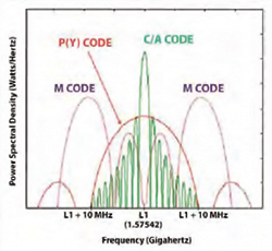
Figure 2. GPS spectrum on L1 (primary GPS frequency)
High-end systems used on military aircraft, ships, and some missiles and munitions are typically part of an integrated navigation system. Oftentimes they operate outside the range of the most likely threat—ground-based jamming. In recent years, attention has mainly focused on low-end users, especially military handheld GPS receivers—also widely used in vehicles. For these users, size, weight, and cost are critical factors, so aircraft anti-jamming techniques offer limited benefits. Toward that end, Air Force Space Command has made GPS modernization and the protection of military signals a priority.
Modernization Of The Global Positioning System
The only practical method of denying the use of GPS to an enemy while limiting the effects to a geographical region involves the employment of local electronic warfare. Unfortunately, GPS civil and military signals share the same frequency range. Although the military originally enjoyed access to a second frequency unencumbered by a civil signal, pressure from civil agencies led to this frequency becoming dual use as well.
After searching for a tractable solution that would enable military use of the GPS in the presence of “friendly” jamming of the civil GPS signal, the Air Force developed a new military signal—military code (M code)—which shares the current GPS frequency bands yet is sufficiently separated from the civil signal to provide secure GPS to military users in the presence of friendly jamming operations against the civil signal.
To meet the direction from the White House and Congress to prevent adversaries from using the GPS, modernized receivers must be robust in the presence of friendly jamming. Spectral separation of the M code signal from civil GPS signals (see the figure below), combined with modern signal processing, will enable war fighters to navigate securely while aggressively jamming enemy use of satellite-based navigation systems. Thus we can ensure space superiority well into the future.
The first satellite with M code launched in 2005, and the 12th one in 2013. By 2017, 24 modernized M-code-capable GPS satellites will supply global coverage and capability to US military and allied users. M code offers several advantages in addition to “spectral separation” (i.e., the frequency allocation of M code does not directly overlay the civilian signals). Its inherent design improves the accuracy and jamming resistance of the military signal, and it includes several enhanced security features. Increased transmitter power aboard the satellite—one of the key attributes of jamming resistance—bolsters the jamming power necessary to defeat friendly receivers, making higher-power jammers easier to detect, locate, and target.
The GPS III satellite program, currently approved for eight modernized satellites, will provide M code signal power up to eight times stronger than legacy military signals supplied by GPS II satellites.13 Although this extra power will not in itself defeat known threats, more power complements every other anti-jamming technique. More power adds more “bars” to the signal meter, providing a signal under tree canopies and possibly in buildings; moreover, it overcomes many annoying, interfering sources that occur regularly in the field. Additional power will come from advanced beam-shaping antennas on future GPS satellites, further improving performance in both impeded and highly jammed conditions.
The GPS has matured in a manner analogous to radar’s development. From the early days of World War II to the present day, an unrelenting pursuit of technologies has yielded tremendous improvements in radar performance. Radar evolved from early continuous-wave radars to monopulse radars, followed by pulse-Doppler radars, phased array radars, and, finally, today’s state-of-the-art synthetic aperture radars. Further, the US military, civilians, and users worldwide rely upon “identification, friend or foe” radar frequencies to distinguish themselves from enemy forces.
Similarly, the original GPS signals were designed in the 1970s, around the same time that Steve Jobs and Steve Wozniak worked on the Apple 1 computer. M code incorporates a modern signal design that enables sophisticated signal-processing techniques which, when combined with the higher signal power on GPS III, will decrease the effective range of enemy military jammers against GPS receivers.
Just as radar has continued to evolve since its inception, so will GPS anti-jamming technologies continue to mature and offer distinct advantages for the US military and allies. In addition to jamming, the GPS has proven vulnerable to “spoofing,” a deception technique using electronic warfare to fool a GPS receiver into locking onto false signals rather than GPS satellite signals.
Professor Todd Humphries of the University of Texas recently testified to Congress that his team of graduate students used a spoofing transmitter to take control of a GPS-guided remotely piloted vehicle, causing it to dive toward the ground.14 The DoD has long known of this threat and has taken measures to prevent it.
Anti-spoofing has always been a feature of military GPS, using encrypted signals as the first line of defense. Moreover, M code cryptography is far more advanced than its older sister, the P(Y) code. Code signed by the GPS Directorate and the National Security Agency, M code is comparable to modern systems that protect much more critical data, and it will protect war fighters from spoofing for decades. Additional measures include smart algorithms incorporated into the Military GPS User Equipment Program, whose receivers can sort out false signals from the satellite signals and reject them, giving the user high assurance.
In the early 2000s, the DoD began employing the Selective Availability Anti-Spoof Module, which introduced over-the-air rekey, over-the-air distribution, and contingency recovery—a technique that resets GPS receivers from possible compromise of the GPS key, thus improving positive control and resiliency. GPS modernization takes this even further. Working with the National Security Agency to leverage its key management infrastructure, US Strategic Command will have even more tools to ensure that only authorized users have access to M code, that the user is protected from spoofing, that keys are readily available to US and coalition partners, and that the drivers of security expenses for user equipment remain minimal.
The launch of the fourth GPS IIF satellite on 15 May 2013 once again has demonstrated Air Force Space Command’s commitment to mission success. Because of the current limitations of the ground-control segment, the launch of this latest satellite will “max out” the constellation with 31 operating satellites at 11,047 nautical miles above the earth in an inclination of 55 degrees to the equator. To ensure continued service, the GPS Program Directorate at the Space and Missile Systems Center, Los Angeles AFB, California, has already delivered five additional GPS IIF satellites to storage, a precedent not attained in well over a decade. These satellites now allow tremendous flexibility to launch on demand when the operational need arises, should a significant series of failures occur.
The GPS Directorate is also investing in the future capability of both the satellite constellation and the ground segment to provide improved command and control of GPS signals. Next-generation GPS IIF and III satellites are in various states of assembly, integration, test, and production in an effort to improve the average user-range error from 0.9 meters—established and maintained for the last three years—to a rootmean-squared user-range error of 0.5 meters by 2016.
Clearly, space superiority is based as much upon PNT accuracy as upon the ability to conduct land, sea, or air operations at a given time and place without prohibitive interference by an opposing force. Toward that end, the GPS III satellite system, with its first launch scheduled for 2015, employs up to eight times the amount of M code power; a designed 15-year lifespan; a new, internationally compatible civil signal (L1C); and greater accuracy.
To maintain a competitive edge over other global navigation satellite systems and to reduce costs, the GPS Directorate is also funding technologies that will provide a return on investment. For example, lithium ion batteries greatly reduce the weight of the satellite, and improved solar cells produce more power at reduced cost, as does the combining of star trackers and inertial measurements into a single component on the spacecraft. Furthermore, digital waveform generation (the ability to change on-orbit signals in space via software commands instead of hardware upgrades, necessarily requiring the launching of new satellites) could become an integral part of the future enterprise architecture.
In addition, the Next Generation Operational Control System (OCX) is designed to command and control our modernized secondary civil signal L2C (1227.60 MHz), safety-of-life signal L5 (1176.45 MHz), and the internationally compatible L1C (1575.42 gigahertz) signal. These additional civil signals include the ability to correct for ionospheric effects and achieve a resulting improvement in accuracy currently enjoyed by military receivers. Importantly, the OCX will no longer be limited to the command or control of only 31 satellites since the system is being designed to accommodate up to 64 GPS satellites. The OCX’s expandability and service-oriented architecture will give users and operators the security, information assurance, and flexibility they simply do not have today.
Affordability + Innovation
Even with all of these improvements, affordability demands innovative ways to deliver the GPS to war fighters. More than 165,000 precision lightweight GPS receivers (PLGR) have been procured worldwide and over 478,000 defense advanced GPS receivers (DAGR) have been ordered (the PLGR and DAGR are the most common military receivers in the DoD).15
The initial DAGR was a marvel, weighing just one pound versus the PLGR’s 2.7 pounds and adding dual-frequency GPS as well as a map display. Both the PLGR and DAGR have become the standard GPS receivers for ground forces. Today, however, most of them (60 to 70 percent) are used in vehicles, often with three or more DAGRs mounted in an Army vehicle, all operating independently. The functionality and user interface of the DAGR, a handheld device, don’t compare well with those of the lightweight, user-friendly commercial devices to which Soldiers have become accustomed. If the DoD designed something equivalent today, it would not keep pace with the innovation and life cycles typical of commercial technology.
The Army recognized this challenge and established a policy in 2009 that called for procurement of embedded receivers, initiating the development of two devices known as the “HUB” and the “PUCK.” In many cases, these new devices will enable the Army to replace up to five DAGRs in a vehicle such as a tank with a single embedded ground card. Embedded devices will also replace the concept of GPS handhelds; instead, systems for dismounted Soldiers will be developed with GPS embedded to support an evolving human interface.
In March of 2012, the Army introduced the Army Marketplace, with 12 initial apps available for iOS devices. Most of these concentrated on training needs and handbooks, but in other research activities, the service has developed and tested other apps for combat support, including augmented reality and navigation.16

Given the ready availability of devices such as smartphones and iPads, it no longer makes sense for the DoD to invest in stand-alone devices with archaic user interfaces. The GPS Directorate is working with Aberdeen Proving Ground to marry commercial off-the-shelf technology, which changes quickly, with secure, enhanced, and robust GPS.
A key cornerstone in our overall strategy entails production of the Common GPS Module. Explicitly designed with a small, minimalist package to support diverse applications, it will prove suitable for integration in a wide range of devices, from smartphones to secure radios. The module will be indistinguishable from the human-machine interface, delivering performance in an electronic warfare environment. Further, it will be a key element of munitions programs such as the small-diameter-bomb direct-attack munition and the precision guidance kit for mortars.
As affordability becomes more important, procurement strategies can adapt according to the mission need. In some cases, situational awareness of an enemy jamming or spoofing in the area may be sufficient. For example, the Rifleman Radio, carried by individual platoon members, is used primarily for voice communications, but it has an inexpensive C/A code chip that reports location to the platoon leader, who has a display. An affordable upgrade may involve providing a secure, lightweight Selective Availability Anti-Spoof Module or M code capability to the platoon leader using the Common GPS Module. Operating procedures could produce the same effect as giving every Soldier the anti-jamming/anti-spoofing capability of M code but at a fraction of the cost.
Many systems may not need M code at all. Consider, for example, the T-6 Texan II, the T-38 Talon, and T1A Jayhawk aircraft, flown primarily at bases in the continental United States for undergraduate pilot training. In such a basic training environment, spoofing and/or jamming is highly unlikely, obviating the need for such code.
As the GPS has become more sophisticated, delivering more capability to both civil and military users, the cost of the spacecraft, including launch, has increased tremendously. The expenditure necessary to put a GPS III in orbit now approaches half a billion dollars. Furthermore, national policy and worldwide expectations are driving the minimum constellation size to 30 satellites on orbit even though a 24-plus-three (on-orbit spares) satellite constellation is considered nominal.17
As aging Block II satellites reach the end of their life span during the next decade, this higher expectation will become burdensome for the DoD. To explore alternatives, Air Force Space Command has initiated an architecture study to define an augmentation strategy with GPS III to reduce the total ownership cost while meeting performance expectations.
This strategy, known as “Navsat,” calls for producing and launching simpler, lighter, and cheaper satellites two or three at a time. Navsat will ensure that the Air Force delivers on the White House’s objective that GPS remain the premiere satellite navigation system in the world. Moreover, by augmenting the GPS III satellite system with eight to 12 cheaper satellites, we can retain competition, bolster the defense industrial base, and reduce total life-cycle costs.
GPS As A Cornerstone Of Space Superiority
In many ways, today’s satellite navigation technology resembles automobile technology in the 1960s. For example, consider some models of the Chevy Vega, whose aluminum engine block warped, or the 1960 Corvair, called by many the most dangerous car ever put on the road.18 Or consider any automobile before the 1964 Mustang, which marketed seat belts as an option until they became mandatory in 1968.
Since the 1960s, cars have incorporated system safety and efficiency features that did not change the fundamental nature of the car but arguably saved lives and reduced costs.
According to the National Highway and Traffic Administration’s estimates, child restraints, seat belts, and airbags saved over 90,000 lives from 2003 through 2007.19 Power steering, power brakes, and fuel injection have improved control and comfort. Fuel emission standards have reduced air pollution in major cities—easily confirmed by observing the thick smog in television shows filmed in Los Angeles in the 1970s. Many of these auto safety initiatives were expensive, premium features when introduced, and resistance to safety legislation from consumers and legislators was intense. Yet, the evolution of the automobile has improved millions of lives.
Similarly, the GPS must evolve, and the delivery of GPS modernization is critical for US battlefield superiority in the future. The GPS was conceived in the late 1960s and early 1970s, deployed in the 1980s, and widely adopted in the 1990s. Anti-jamming and anti-spoofing are like seat belts and air bags insofar as they improve the reliability and availability of precision PNT to aircraft, bombs, ships, vehicles, communications systems, and personnel. Enhanced signal and key management are like power steering and power brakes insofar as they make the system more effective and efficient.
Just as Congress specified requirements for seat belts, so does Title 10 United States Code, section 2281, demand that all military GPS receivers be M-code capable. And just as the seat belt met resistance, so is there reluctance to program M code receivers into the Future Years Defense Program even though, like the automobile, M code receivers—in terms of safety—will be superior to commercial receivers.
The GPS has its competitors, the most formidable of which have the backing of their national sponsors. The Russians have reinvigorated their Global Navigation Satellite System (GLONASS) and since October 2011 have provided a full 24-satellite constellation for the first time since late 1995. The Chinese are rapidly populating the satellite constellation of their BeiDou system but actually rely on the GPS constellation to operate fully. The Japanese Quasi-Zenith Satellite System augments the GPS through highly inclined satellites with long dwell times over the home islands. The European Union has recently committed to buying what will become a full-complement system with 30 satellite vehicles.
The GPS is—and for the foreseeable future will remain—the best global satellite navigation system in the world, and the United States has the ability to retain the space superiority enabled by the GPS. Like a high-performing NASCAR team, America must continue to rely on engineering excellence, innovative management, and sustained operational excellence to maintain the leadership position that the GPS now enjoys.
The United States and the Airmen who provide this vital global utility free of charge for the world should be justifiably proud of its history and capabilities. The GPS must continue to evolve as warfare evolves. As General Giulio Douhet aptly observed, “Victory smiles upon those who anticipate the changes in the character of war, not upon those who wait to adapt themselves after the changes occur.”20
Notes
1The GPS is a space-based positioning, navigation, and timing system. With a constellation of at least 24 satellites (currently more than 30) in medium Earth orbit, it provides global positioning and timing by broadcasting radio frequency signals at three frequencies in the L-Band: L1 (1575.42 megahertz [MHz]), L2 (1227.6 MHz), and L5 (1176.45 MHz). The user’s GPS receiver obtains position and time by tracking four or more satellites and determining the time of arrival of each radio signal, which propagates at the speed of light. For more information on GPS, see “The Global Positioning System,” GPS.gov, 17 January 2013, http://www.gps.gov/systems/gps/.
2 Joint Publication 3-14, Space Operations, 29 May 2013, GL-8, http://www.dtic.mil /doctrine/new_pubs/jp3_14.pdf.
3 “Desert Storm: The First Space War,” in Gray Space and the Warfighter, 17 June 1997, http://www.au.af.mil/au/awc/awcgate/grayspc/dstorm/dstorm.htm.
4 Ibid.
5 The GPS is integral to nearly all smartphones today. According to CNET, “During the third quarter [of 2012], the total installed base for smartphones worldwide hit 1.04 billion, jumping from the 959 million smartphones in use during the second quarter, research firm Strategy Analytics announced today.” Don Reisinger, “Worldwide Smartphone User Base Hits 1 Billion,” CNET, 17 October 2012.
6 Nam D. Pham, PhD, The Economic Benefits of Commercial GPS Use in the U.S. and the Costs of Potential Disruption (Washington, DC: NDP Consulting Group, June 2011), 1, http:// www.saveourgps.org/pdf/GPS-Report-June-22-2011.pdf.
7 “Because the Global Positioning System (GPS) was so accurate (although not as accurate as laser-guided bombs) and could be used in all weather, the Joint Direct Attack Munition was the favorite. While designed to be used against high-value, fixed targets, JDAMs were heavily used against relatively low-value targets and in close air support missions flown by bombers at relatively high altitudes. The extensive use of precision-guided munitions greatly improved the Air Force’s ability to hit targets, in any weather.” Kristin F. Lynch et al., Lessons from Operation Iraqi Freedom (Santa Monica, CA: RAND Corporation, 2005), 95, http://www.rand.org/content/dam/rand/pubs/monographs/2005/RAND_MG193.pdf.
8 “Selective Availability (SA). Protection technique employed by DoD to deny full system accuracy. On May 1, 2000, President Clinton announced the discontinuance of SA effective midnight 1 May 2000. The effects of SA went to zero at 0400 UTC on 2 May 2000.” Department of Defense, Global Positioning System Standard Positioning Service Performance Standard, 4th ed. (Washington, DC: Department of Defense, September 2008), C-4, http:// www.gps.gov/technical/ps/2008-SPS-performance-standard.pdf.
9 “Instantaneous User Range Error (URE). An instantaneous URE is the difference between the pseudorange measured at a given location assuming a receiver clock that is perfectly calibrated to GPS time and the expected pseudorange as derived from the NAV [navigation] message data for the given location and the assumed receiver clock. The instantaneous SIS URE [signal-in-space user-range error] includes only those pseudorange data set error budget components assigned to the GPS Space and Control Segments (i.e., not including the error budget components assigned to the GPS User Segment such as the troposphere delay compensation error, multipath, and receiver noise).” Ibid., C-2.
10 Ibid., 22.
11 Presidential Decision Directive NSTC-6, US Global Positioning System Policy, 28 March 1996, http://www.fas.org/spp/military/docops/national/gps.htm.
12 United States Strategic Command, Joint Capabilities Document for Position, Navigation, and Timing (Offutt AFB, NE: United States Strategic Command, 28 September 2006), 4. FOUO. Information extracted is unclassified.
13 GPS II refers to the second generation of GPS satellites although Block II was actually the first series of operational GPS satellites. The designators IIA (advanced), IIR (replenishment), and IIF (follow-on) represent the versions of Block II satellites. To date, four of 12 IIF satellites have been launched.
14 House, Professor Tom Humphreys, Statement on the Vulnerability of Civil Unmanned Aerial Vehicles and Other Systems to GPS Spoofing, Submitted to the Subcommittee on Oversight, Investigations, and Management of the House Committee on Homeland Security, 112th Cong., 2nd sess., 19 July 2012.
15 Data obtained from GPS User Equipment Division contracts.
16“Another app, called ‘sSoldierEyes,’ turns a smartphone into a sort of battlefield navigation device. In addition to displaying a digital map, it features an “augmented reality’ mode that enables the user to flip on the camera and scan the horizon. Digital markers pop up on the screen, displaying the direction and distance to objectives on the battlefield.” Nathan Hodge, “Killer App: Army Tests Smartphones for Combat,” Wall Street Journal, 3 June 2011, http://online.wsj.com/article/SB10001424052702304563104576361480888426472.html.
17 “According to Dr. Sheila E. Widnall, Secretary of the Air Force, the Air Force recognizes the tremendous civil and military aspects of GPS, and fully intends to maintain a 24-satellite constellation for the duration of the program.” “President Opens Door to Commercial GPS Markets: Move Could Add 100,000 New Jobs to Economy by Year 2000,” press release (Washington, DC: White House, Office of the Press Secretary, 29 March 1996), http://clinton3.nara.gov/WH/EOP/OSTP/html/gps-pressrel.html.
18 “The Most Dangerous Cars of All Time,” CarsDirect.com, 24 February 2012, http://www.carsdirect.com/automotive-news/the-most-dangerous-cars-of-all-time.
19 National Highway Traffic Safety Administration, Lives Saved FAQs (Washington, DC: National Highway Traffic Safety Administration, December 2009), 4, http://www-nrd.nhtsa .dot.gov/Pubs/811105.PDF.
20 Giulio Douhet, The Command of the Air, trans. Dino Ferrari (1942; new imprint, Washington, DC: Office of the Air Force History, 1983), 30.

About the authors
Colonel Gruber (BSME, North Dakota State University; MSBA, Central Michigan University) is the director of the Global Positioning Systems Directorate. He is responsible for a multi-service, multinational systems directorate that conducts development, acquisition, fielding, and sustainment of all Global Positioning System (GPS) space segment, satellite command and control (ground), and military user equipment. The $32 billion GPS program, with a $1 billion annual budget, maintains the largest satellite constellation and the largest avionics integration and installation program in the Department of Defense. Commissioned in 1986, Colonel Gruber is a graduate of Squadron Officer School, Air Command and Staff College, Air War College, Defense Systems Management College, and Joint Forces Staff College, and has commanded at the squadron, group, and wing levels.
A member of the Acquisition Corps, he is a certified joint specialty officer and National Defense Fellow alumnus. Colonel Gruber has distinguished himself in a variety of leadership positions within the operations, intelligence, launch, engineering, and acquisition disciplines. He has served in key positions at major command, Air Staff, Joint Staff, and Defense Agency levels. Prior to assuming his current position, Colonel Gruber served as one of four mission panel chiefs on the Air Staff, responsible for future budgeting for all space and intelligence, surveillance, and reconnaissance programs across the Air Force.

Colonel Anderson (BSEE, University of Kansas; MSEE, South Dakota State University; PhD, Air Force Institute of Technology) is the former chief of the Global Positioning System (GPS) User Equipment Division. He was responsible for leading over 299 military, civilian, and contractor personnel executing multiple development and production contracts valued at more than $2 billion and delivering secure GPS capabilities to Department of Defense and allied users. Commissioned in 1988, Colonel Anderson is a graduate of Squadron Officer School, Air Command and Staff College, and Naval War College.
He has commanded at the squadron and group levels and has a broad Air Force background, with experience in missile operations, technical intelligence analysis, systems engineering, operational test support, national and international space policy, and program management. Colonel Anderson was recently recognized by the Institution of Navigation as the recipient of the 2012 Captain P. V. H. Weems Award for sustained contributions to modernized military GPS, leading enhanced capabilities for US and allied military operations in a navigation warfare environment.
Editor’s note
Our thanks to Air & Space Power Journal for permission to republish this informative article. For further information on ASPJ, please visit http://www.airpower.au.af.mil/