
One of the first things many people think of when they think about the U.S. Space Force (USSF) is the Global Positioning System (GPS).
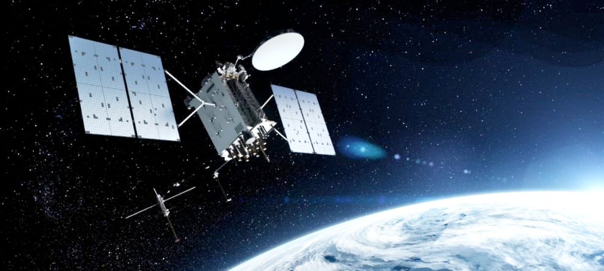
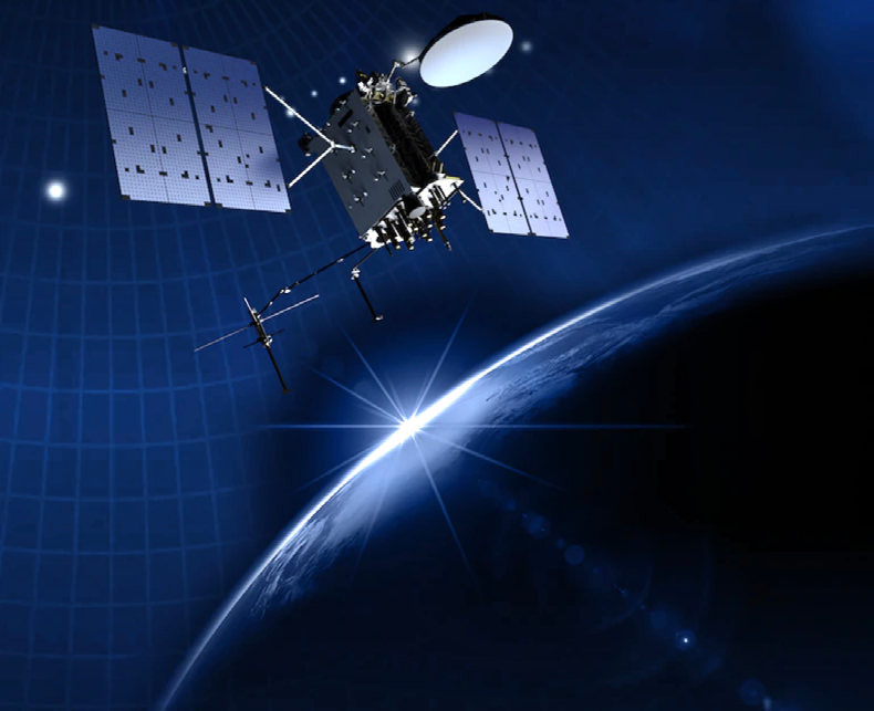
Artistic rendition of a GPS III / IIIF satellite, courtesy of Lockheed Martin.
The USSF’s Space Systems Command is the executive agent for the U.S. Department of Defense for acquiring GPS satellites and user equipment, and also sustaining the satellites and ground control segment systems which are operated and controlled by Space Delta 8 at Schriever Air Force Base in Colorado.

Barbara J. Baker
“GPS has become a world utility – we provide free access to the world,” said Barbara J. Baker, deputy program executive officer of Military Communications and Positioning, Navigation and Timing (PNT) at SSC.
“Businesses have been built on the use of position, navigation and timing,” Baker said. “The world’s economy relies on GPS: whether it’s the navigation piece that we know from our cars, the timing that the banking industry relies on for currency conversion rates, to positioning and navigation for trucking and shipping.”
She continued, “It has been so ingrained in our economy — if you woke up, turned on your lights, went into your refrigerator and grabbed some fresh produce, and then got some money from the ATM, all of that relies on GPS. So many people do not realize how much of our world relies on some element of that signal in space that we’re publishing out.”
Although it’s hard to imagine a world without GPS today, the GPS project was started by the U.S. Department of Defense in 1973, with the first prototype launched in 1978 and a full constellation of 24 satellites operational by 1993. Col. Brad Parkinson, lead architect of the U.S. Air Force NAVSTAR program, the forerunner of GPS, is widely credited as the godfather of GPS, along with Ivan Getting, founding president of The Aerospace Corporation, and Roger Easton, American physicist and state representative.

Bruno A. Mediate Jr.
“It started as a design concept for navigation in space, using space-based assets,” said Bruno A. Mediate Jr., director, GPS Product Support Delta for SSC’s MilComm & PNT Directorate. “It was really approved because it also offered opportunities for nuclear detonation detection during the height of the Cold War – so what we know today as Positioning, Navigation and Timing has a dual purpose with a payload that could also be used for nuclear detonation detection and location.”
“It was a hard sell,” Baker said. “GPS really existed because the nuclear detonation detection payload was going to be on a GPS vehicle.”
The DoD soon found numerous uses for the new technology in military operations, including: aerial rendezvous and refueling, all-weather air drops, instrument landings, mine laying and mine sweeping, anti-submarine warfare, bombing and shelling, photo mapping, range instrumentation, rescue missions and satellite navigation.
GPS proved particularly useful during the U.S. involvement in Operations Desert Shield and Desert Storm. Allied troops relied heavily on GPS to navigate the Arabian Desert. During Operations Enduring Freedom, Noble Eagle and Iraqi Freedom, GPS again provided important intelligence to U.S. troops.
During Operation Iraqi Freedom, GPS satellites allowed the delivery of 5,500 GPS-guided Joint Direct Attack Munitions with pinpoint precision that reduced collateral damage — nearly one quarter of the total number of bombs and missiles that coalition forces released against Iraqi targets.
Non-military use was approved in 1983 by then President Ronald Reagan, following an incident where a Korean airliner accidentally entered Soviet air space due to a navigational mistake and was shot down.
The current USSF GPS constellation consists of 31 operational satellites orbiting the Earth in Medium Earth Orbit (MEO), or about 12,550 miles above the Earth. There also are “residual” satellites that can be swapped in for testing or supplementing
the operational constellation, Mediate said. The MEO orbit passes through the Van Allen radiation belts, which means the satellites must be designed to survive a particularly harsh space environment, Baker said.
These satellites orbit the earth every 12 hours, emitting continuous navigation signals. With the proper equipment, users can receive at least four satellite signals from space to calculate time, location and velocity. The signals are so accurate, time can be configured to within a millionth of a second, velocity within a fraction of a mile per hour and location to within 43 centimeters, Baker said.
“While GPS provides the position, navigation and timing — it’s all about the accuracy of keeping time — that’s what everything gets calculated off of,” Mediate said. “Our frequency standards, which are the atomic clocks on the satellites, provide the accuracy to keep time. And that accuracy of timing allows for mathematic calculation to then track position, navigation, and velocity from the signals that come from the satellite.”
“GPS is not just a signal in space,” Baker said. “You need three segments: the space segment, which is built up of a constellation of Boeing and Lockheed Martin satellites on orbit; the control segment, the ground- based hardware and software that tracks, monitors and updates the satellites; and then you have the user segment that receives and processes the signals.”
GPS satellites have been released in blocks — or series of satellites — with new improvements for each iteration: Block I (1978-1985); Block II (1989-1990); Block IIA (1990-1997); Block IIR (1997-2004); Block IIR-M (2005-2009); Block IIF (2010-2016); and the latest, Block III. Block III consists of 10 satellites, each weighing about 5,003 pounds, compared to 4,480 pounds for Block IIR-M satellites.
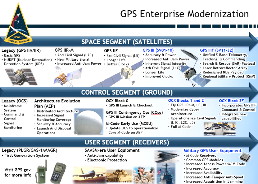
The sixth GPS III satellite is scheduled to be launched in January of 2023, but the launching of GPS III SV5 – nicknamed “Armstrong” on June 17, 2021 — marked a significant milestone by becoming the 24th Military Code (M-code) capable satellite on orbit, Mediate said. The M-code signal has greater resistance to jamming, and a new, fourth civil signal, L1C, on the GPS III satellites will be compatible with signals from the European Space Agency’s Galileo navigation satellite system.
“With the Block III satellites, we have power management that enables more power to be flexed between the different signals,” Mediate said. “Increased power means we can persist through any jamming and provides for greater anti-spoofing capability.”
The next-generation, operational control segment — known as OCX — will be replacing the current GPS ground system OCS, Baker said. During the COVID pandemic, SSC’s PNT team installed 17 world-wide monitoring stations, deployed the operational equipment into the field, and added an OCX element to the four Legacy Ground Antenna. OCX is in the final integration stages and software qualification testing.
GPS III satellites have a design life of 15 years, compared to 12 for the GPS IIF block satellites, and offer three times the greater navigational accuracy and signal power. However, many of the older satellites have far exceeded their expected lifespan: the longest-serving GPS satellite is an IIR-2 satellite that was launched in July 1997.
“Some of our satellites are now of drinking age,” Baker said. “GPS is a world utility and the U.S. is most robust and the gold standard because we’ve been doing it for so long and because of the number and capability of satellites we have in space. But within the GPS navigation community, there are other countries that are developing a GPS-like navigation constellation.”
Russia has the Russian Global Navigation System, GLONASS; China has the BeiDou Navigation Satellite System; the European Union has the Galileo navigation system; India’s NavIC; and Japan has the Quasi-Zenith Satellite System (QZSS).
Because the world relies so heavily on GPS, SSC “is working collaboratively with our space operational partners in Space Delta 8 and the 2nd Space Operations squadron to identify what we can do with tactics, techniques and procedures to protect our space assets,” Mediate said. “What makes GPS unique is that the U.S. has made a commitment to the international community for the availability and integrity of the GPS signal. Other countries have not made that level of commitment internationally, which is what makes U.S. GPS at the present time the gold standard for international use and why we call it a global navigation satellite system.”
Contact Space Systems Command at SSC@spaceforce.mil— C@spaceforce.mil
follow on LinkedIn.