
When we look back half a century, the Soviet Union and the United States were the only players operating within the realm of space exploration. Fast forward to the present day and we can see more than 80 nations making efforts to enter space.

As exploration continues, the world’s reliance on space is growing ever more pronounced, as it has yielded a plethora of innovations, including breakthroughs in telecommunications and critical applications for applications in national security. Space technology has also found its way into everyday life.
By the second quarter of 2023, there were >11,000 individual satellites orbiting the Earth that have been launched since the international foray into space started — however, out of this number, >3000 (according to the Union of Concerned Scientists - UCS) are inactive, useless hunks of metals that are posing risks to space assets as well as human life.
The sheer volume of the objects in space, coupled with the increasing congestion in space, has sparked the urgency of developing and maintaining reliable Space Situational Awareness (SSA) — or Space Domain Awareness (SDA) — capabilities.
What Is SSA?
Space Situational Awareness involves tracking and maintaining complete data on all space objects, understanding their activities, monitoring space weather events, identifying potential threats, and more.
SSA needs are growing as nations continue to develop and launch more objects into space. (Please see Figure 1.)
This surveillance includes active space objects as well as other types of debris. The role of SSA behind the collection all this crucial information cannot be ignored, as the gathering of this important data from space is an exceptionally challenging task.
SSA requires a network of globally distributed radars, sensors and many other device types.
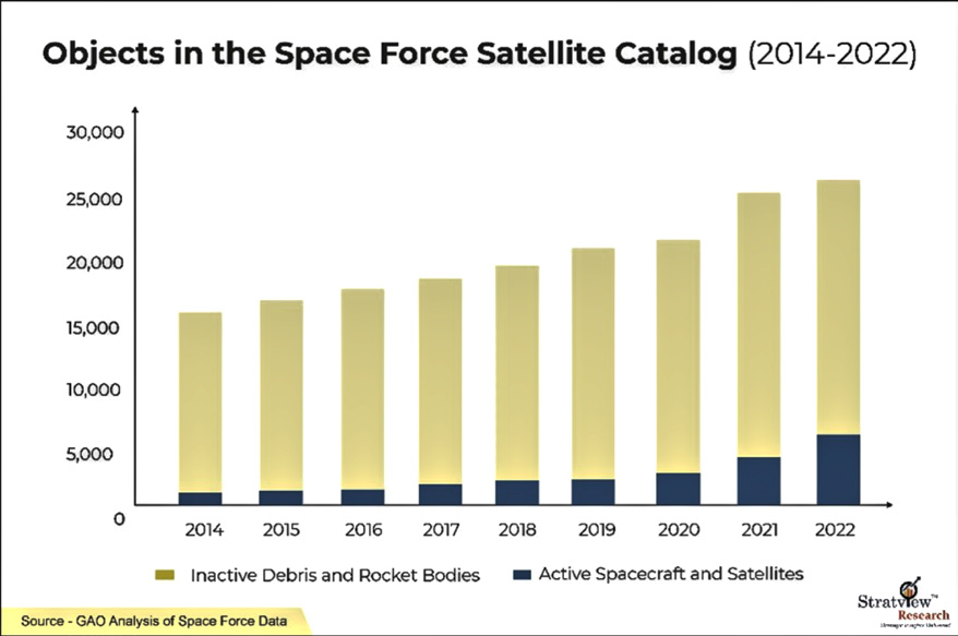 Figure 1. SSA capabilities and solutions.
Ground-based radars consist of at least one transmitter that emits radio waves at a particular frequency and are measured by the receiver, which calculates the location of the targeted object.
Advanced ground-based radars can track many objects simultaneously, detecting their motion, shape, and so on. Due to their complexity, these radars are quite costly and their size is also a disadvantage.
Optical telescopes are also widely used for SSA purposes. These telescopes collect light or emitted electromagnetic radiation or reflection from objects in space using lenses, mirrors, or both.
They can cover a large area easily and quickly — specifically, they can track objects above 5,000 km. in altitude. To provide high-resolution images, these telescopes require specific lighting conditions and clear skies.
Different types of sensors are also used for SSA purposes. These sensors detect radio frequencies or other signals from the satellites and this data enables them to accurately measure the distance or range of the objects.
The use of lasers for SSA is another option as they are able to precisely measure the distance of a satellite.
Increased Space Traffic and Congestion
Global dependency on space has been growing rapidly over the years. Over the past 5 years, the number of active satellites has seen a meteoric rise from just over 2,000 in 2018 to nearly 7,000 in 2023. (See Figure 2.)
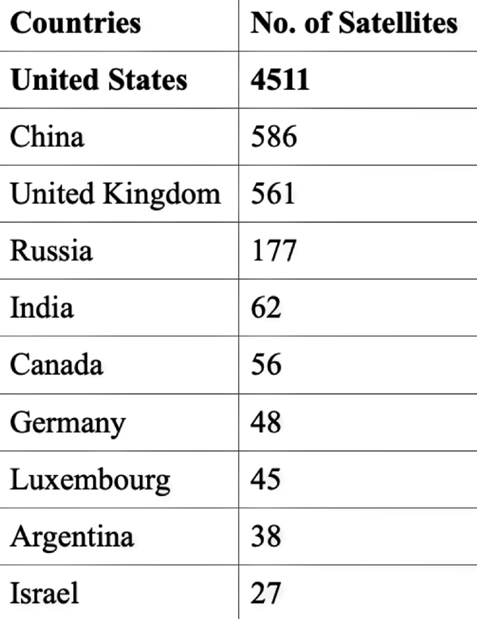
When it comes to space traffic, the largest number of satellites launched were by the U.S., followed by China, UK, and Russia (acc. to the data till 2022). The U.S. holds the top position in the field of space exploration, as
evidenced by its extensive military /agency / government (MAG) and commercial satellite launches, as well as the nation’s significant influence over key, space technology companies.
In numbers, through the end of 2022, the U.S. was at the forefront, with more than half of the total satellite fleet.
No doubt that the U.S. boasts the highest number of satellites due to the SpaceX constellations.
Similarly, the OneWeb constellation is the reason behind the UK’s satellite count.
Argentina owes its satellite numbers to Satellogic satellites, and Luxembourg’s satellite count can be attributed to the SES communication satellites.
The Threat
When it comes to space congestion, “what goes up, doesn’t always come down,’ often proves to be correct.
With the launch of the first satellite into space, human- manufactured debris started to compile in various orbits. The worst event that created a huge debris field was in 2007, when China intentionally destroyed their own weather satellite. This action added more than 3,500 pieces of large, trackable debris and far more smaller fragments to the space junk.
Debris in space travels at roughly 10 kilometers/second.
A collision with any object moving that fast is obviously in danger. Even a pencil-point-sized piece of junk (about a millimeter in size) can destroy a spacecraft’s mobility or even the unit itself.
In 2021, a two inch piece of space junk punched a tiny hole into the International Space Station (ISS), damaging one of the station’s robotic arms.
That incident was described as a near miss, but as the debris count increases, so does the possibility of many more future collisions.
The Department of Defense’s Space Surveillance Network (SSN) tracks more than 27,000 pieces of orbital debris. However, there exists far more debris that is too small to be tracked, but large enough to threaten human space missions. Various estimates suggest presence of at least 100 million pieces of useless space waste between one millimeter and ten centimeters.
As both governments and the private sector ramp up their continued space explorations, governments are focusing on cleaning the debris fields.
Entities such as the European Space Agency (ESA) established guidelines for space debris mitigation and junk removal. ESA also plans to remove junk by using a ClearSpace spacecraft by 2025.
The United States’ National Orbital Debris Implementation Plan categorizes measures to mitigate the risks associated with debris into three main areas:
1. Minimizing the generation of new debris
2. Monitoring and characterizing existing debris
3. Developing methods to address and remove existing debris.
Apart from government bodies, there are other institutes and commercial players that are stepping up for clean- space mission.
One example is AstroScale’s ADRAS-J RemoveDEBRIS mission aims to capture ~40,000 pieces of space debris and is scheduled to embark on its space-cleaning mission in 2025.
Developing SSA Capabilities
According to Stratview Research, the worldwide SSA market is estimated to reach $2 billion by 2028, experiencing an annual growth of more than 5% during the next five years.
At present, the U.S. military has the most advanced SSA capabilities, using radar and a number of tracking devices that track even small objects in Low Earth Orbit (LEO).
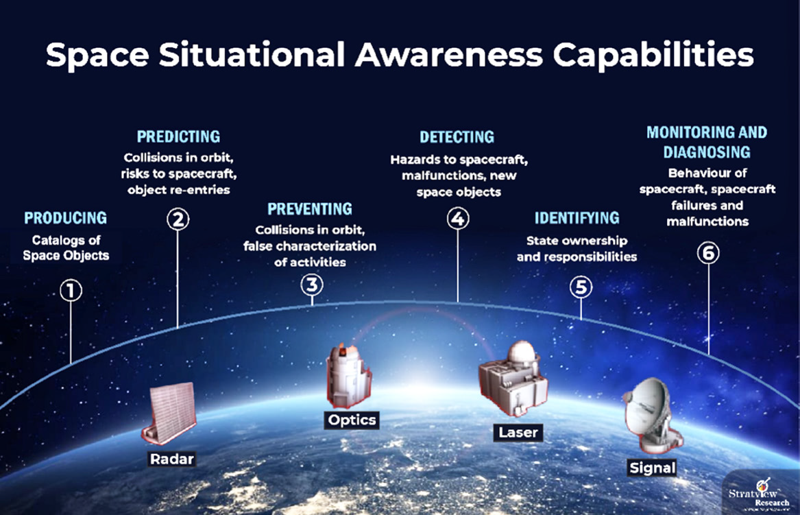 Figure 2. Objects in the USSF satellite catalog.
The Russian civilian space agency Roscosmos operates the Automated Warning System on Hazardous Situations in Outer Space, using data from the International Scientific Optical Network (ISON) and other Russian SSA assets.
Countries such as China, Japan and India also have significant satellite tracking, telemetry, and control assets and are investing in significant, new, SSA capabilities and data-sharing programs.
For instance, India uses a Multi Object Tracking Radar for SSA purpose. As it covers only a limited range, the nation seeks data assistance from NORAD (North American Aerospace Defence Command) and other resources that are available in the public domain.
The U.S. and South Korea have agreed to cooperate on SSA for military purposes and there are countries that are moving forward to achieve ‘no-dependency’ and strategic autonomy in space traffic management. During a session at the 15th European Space Conference held in January of 2023, the ESA stated that they are working on reducing reliance on the U.S. for SSA solutions.
Over the past few years, a major portion of laucnhed satellites were tasked for communication capabilities.

With the robust growth in new-age technologies such as 5G, Artificial Intelligence (AI), and Internet of Things (IoT), there will be even more satellites on-orbit during the next decade to serve global communication requirements. Some experts cite the potential of 58,000 additional active satellites will be launched by 2030.
Launching a single satellite into space costs millions of dollars and can require several months (sometimes years) for the design, development and manufacturing to be completed.
After a satellite has reached its orbital slot, a collission with any space debrus could eliminate that spacecraft’s ability to correctly function — that satellite could then be of no use to anyone.
If an encounter with debris occurs, the entire process of launching another satellite will have to be repeated at additional cost and loss of time and data reception and such could be both econmically and technologically disasterous.
As an old adage states,“Prevention is better than the cure.” SSA is in dire need and is far more than simply a choice for nations — SSA is critically important to ensure MAG and commercial capabilities remain fully functional by the spacecraft on-orbit to improve, as well as save, human life.
www.stratviewresearch.com