Lockheed Martin + Us Navy—It’s A Hand-Off
Lockheed Martin has completed on-orbit testing of the second Mobile User Objective System (MUOS) satellite and handed over spacecraft operations to the U.S. Navy.
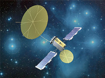
The handover also includes acceptance of three MUOS ground stations that will relay voice and high-speed data signals for mobile users worldwide. MUOS-2 was launched July 19, 2013 aboard a United Launch Alliance Atlas V rocket from Cape Canaveral Air Force Station, Florida.
The system dramatically improves secure communications, delivering simultaneous and prioritized voice, video and data for the first time to users on the move.
“MUOS-2 benefits from continuous improvement. We completed our baseline on-orbit testing in half the time compared to MUOS-1,” said Iris Bombelyn, vice president of Narrowband Communications at Lockheed Martin.
“We look forward to supporting the Navy’s test and evaluation phase to demonstrate the total capability of the Mobile User Objective System. When commissioned, the full digital data and flexible network management capabilities will be available to users for both MUOS-1 and MUOS-2.”
The Naval Satellite Operations Center will soon begin relocation operations to place MUOS-2 in its operational slot. There, it will undergo testing and evaluation prior to formal government commissioning in 2014.
MUOS satellites are equipped with a wideband code division multiple access (WCDMA) payload that provides a 10-fold increase in transmission throughput over the current Ultra High Frequency (UHF) satellite system, which is also on board.
The WCDMA payload gives users the advantage of high-speed data and priority access that legacy systems did not.
Lockheed Martin’s MUOS operations team conducted the on-orbit deployment and checkout of all spacecraft systems over a four month period.
The spacecraft systems and integrated ground and network systems were evaluated with three radio access facilities and new MUOS-compatible terminals.
A growing number of terminals are taking advantage of the MUOS advantage since first connections with the advanced waveform began earlier this year.
Government testing will take place before MUOS-2 is turned over to U.S. Strategic Command for operational use.
* * * * * * * * *
International Launch Services + Inmarsat—Launch Is A Breeze
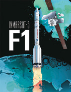
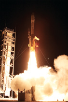
The most recent ILS launch of the Inmarsat-5 F1 satellite on December 8th will bring data services to both commercial and government users who could be on land, sea and in the air.
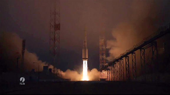
Photo of the Proton Breeze launch of the Inmarsat-5 F1 satellite is courtesy of International Launch Services.
To generate such high power, each spacecraft’s two solar wings employ five panels each of ultra triple-junction gallium arsenide solar cells.
The Proton booster that launched the Inmarsat-5 F1 satellite was 4.1m (13.5 ft) in diameter along its second and third stages, with a first stage diameter of 7.4m (24.3 ft). Overall, height of the three stages of the Proton booster was 42.3m (138.8 ft).
The Proton vehicle’s history, built by Khrunichev Research and State Production Center, includes nearly 400 launches since 1965. Khrunichev Research and State Production Center is a major player of the global space industry, and the majority owner of ILS.
The first stage consists of a central tank containing the oxidizer surrounded by six outboard fuel tanks. Each fuel tank also carries one of the six RD-276 engines that provide first stage power. Total first stage vacuum-rated level thrust is 11.0 MN (2,500,000 lbf).
Of a conventional cylindrical design, the second stage is powered by three RD-0210 engines plus one RD-0211 engine and develops a vacuum thrust of 2.4 MN (540,000 lbf).
Powered by one RD-0213 engine, the third stage develops thrust of 583 kN (131,000 lbf), and a four-nozzle vernier engine that produces thrust of 31 kN (7,000 lbf). Guidance, navigation, and control of the Proton M during operation of the first three stages is carried out by a triple redundant closed-loop digital avionics system mounted in the Proton’s third stage.
Each Inmarsat-5 satellite will carry 89 Ka-band beams that will operate in geosynchronous orbit with flexible global coverage. The satellites are designed to generate approximately 15 kilowatts of power at the start of service and approximately 13.8 kilowatts at the end of their 15-year design life.

The mission used a five-burn Breeze M mission design, using the Supersynchronous Transfer Orbit mission design.
The first three stages of the Proton used a standard ascent profile to place the orbital unit (Breeze M upper stage and the Inmarsat-5 F1 satellite) into a sub-orbital trajectory.
This Inmarsat satellite is one of three Ka-band Inmarsat-5 satellites that were ordered from Boeing by the London-based company, at a cost of about $1 billion under a fixed-price contract, with options.
“We remain focused on continuing to complete crucial milestones to successfully deliver this series of
satellites,” said Craig Cooning, vice president and general manager of Boeing Space & Intelligence Systems.“The spacecraft has two solar wings with five panels, each of ultra triple-junction gallium arsenide solar cells. The BSS-702HP carries the xenon ion propulsion system (XIPS) for all on-orbit attitude control.”
When operational, the Inmarsat-5 satellites will provide Inmarsat with a comprehensive range of global mobile satellite services, including mobile broadband communications for deep-sea vessels, in-flight connectivity for airline passengers and streaming high-resolution video, voice and data with the ability to adapt to shifting subscriber usage patterns of high data rates, specialized applications and evolving demographics.
The Boeing 702HP carries the xenon ion propulsion system (XIPS) for all on-orbit maneuvering.
When operational, the Inmarsat-5 satellites will provide Inmarsat with a comprehensive range of global mobile satellite services, including mobile broadband communications for deep-sea vessels, in-flight connectivity for airline passengers and streaming high-resolution video, voice and data.
Also, in a separate arrangement, Boeing also entered into a distribution partnership with Inmarsat to provide L- and Ka-band capacity to key users within the U.S. government.
This launch marks the seventh ILS Proton launch in 2013, the 84th ILS Proton launch overall, the third Inmarsat satellite to be launched on Proton and the 16th Boeing satellite launched on an ILS Proton.
* * * * * * * * *
USMC—Ensuring Safety During Operation Damayan
Marines with 3rd Marine Expeditionary Brigade, in support of Joint Task Force 505, set up an air traffic navigational, integration and coordination system at Tacloban airport, Leyte, Republic of the Philippines, November 17th during Operation Damayan.

Marines lock the satellite dish of an air traffic navigational, integration and coordination system during Operation Damayan at Tacloban airport November 18. The 3rd Marine Expeditionary Brigade is assisting the Philippine government’s ongoing relief efforts in response to the aftermath of Typhoon Haiyan. The Marines are with Marine Air Control Squadron 4 currently assigned to 3rd MEB in support of Joint Task Force 505. (U.S. Marine Corps photo by Lance Cpl. Stephen D. Himes/Released)
The system allows air traffic controllers to contact incoming and outgoing aircraft and analyze flight patterns. Additionally, the controllers use the mobile system to guide pilots through their final approach to the runway when visibility is poor.
“The last time we were able to use the system was during an exercise, and now it is going to play an effective role during a real-world operation,” said Gunnery Sgt. Lee A. Pugh, a radar chief with Marine Air Control Squadron 4, currently assigned to 3rd MEB.
The air traffic control tower at Tacloban airport was severely damaged by Typhoon Haiyan and is limited in its ability to manage the high volume of daily air traffic. The system will assist the Philippine Air Force in operations based out of Tacloban.
With the system in place the Philippine Air Force will better be able to manage multiple flights at once, according to Sgt. Jonathan Haasl, a radar electronics technician with MACS-4.
With frequent inclement weather in the Asia-Pacific region, the system plays a vital role in assuring the pilots, crews, aircrafts and most importantly, the aid supplies make it safely to their destination, according to Pugh.

An MV-22B Osprey prepares to take off near an air traffic navigation, integration and coordination system here November 20 as part of Operation Damayan, a humanitarian and disaster relief operation underway in the Philippines. The expeditionary navigation system provides air traffic controllers a platform to guide and direct aircraft in the absence of a typical tower. The system was deployed for the first time in response to Typhoon Haiyan, which struck the Philippines, November 7 with estimated sustained winds of more than 200 mph. Photo by Lance Corporal Anne Henry, Marine Expeditionary Force / Marine Corps Installations Pacific
“There are several components that make up the system, like the portable electric units, air-surveillance radar system, radios and a precision approach radar system,” said Pugh.
The unit’s expeditionary capabilities are enhanced due to the mobility of the system.
“The unique feature of the system being mounted on multipurpose-tactical vehicles makes it easy for us to move to essential areas where it can make a difference, while not wasting valuable time,” said Pugh.
The system is a key capability of Marine Corps crises response around the world, whether a humanitarian assistance and disaster relief scenario or contingency operations.
“The system provides on the spot air surveillance and a rapid response, which is useful to expeditionary airfields like the one at Tacloban,” said Col. Brian W. Cavanaugh, the commanding officer for the 3rd MEB aviation combat element.
Besides bringing precision approach information to aircraft preparing to land, it is also useful in joint and bilateral operations, providing a safer environment for aircraft in the area, according to Cavanaugh.
“The safety of all the people on the aircraft is the most important part of the mission,” said Cavanaugh. “With this system, we can guide pilots to a three foot by three foot square safely and efficiently.”
Story by Corporal Jose Lujano, III Marine Expeditionary Force / Marine Corps Installations Pacific
* * * * * * * * *
Northrop Grumman + NATO—The First Global Hawks Now In Production
Northrop Grumman Corporation’s Moss Point, Mississippi, Unmanned Systems Center has started production of the first NATO Alliance Ground Surveillance (AGS) Block 40 Global Hawk aircraft, enhanced to meet NATO operational requirements.
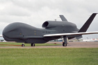
Photo of the NATO version of the Global Hawk UAV.
The system will provide NATO with unprecedented near real-time terrestrial and maritime situational awareness information throughout the full range of NATO military and civil-military missions, including peacekeeping and humanitarian relief operations.
The NATO AGS system will be a major contribution to NATO’s joint intelligence, surveillance and reconnaissance (ISR) capability.
The NATO AGS system will be equipped with the multimode Multi-Platform Radar Technology Insertion (MP-RTIP) airborne ground surveillance radar sensor to provide all-weather, day or night intelligence to the NATO Alliance. The system also includes an extensive suite of network-centric enabled line-of-sight and beyond-line-of-sight long-range, wide-band data links.
“With the ability to fly up to 60,000 feet and for more than 30 hours, the NATO AGS system is uniquely suited to support NATO missions worldwide,” said Jim Culmo, vice president, High-Altitude, Long Endurance Enterprise, Northrop Grumman Aerospace Systems.
The NATO AGS system also includes European-sourced ground assets that will provide in-theater support to commanders of deployed forces. Mobile and transportable ground stations will provide an interface between the AGS core system and a wide range of interoperable NATO and national command, control, intelligence, surveillance and reconnaissance systems.
NATO is acquiring the system with 15 nations participating including Bulgaria, Czech Republic, Denmark, Estonia, Germany, Italy, Latvia, Lithuania, Luxembourg, Norway, Poland, Romania, Slovakia, Slovenia and the United States.

The NATO Alliance Ground Management Agency awarded the prime contract for the system to Northrop Grumman in May 2012 during the NATO Summit. The company’s primary industrial team includes EADS Deustchland GmbH (Cassidian), Selex ES and Kongsberg, as well as leading defense companies from all participating nations. The NATO AGS system is a variant of the combat-proven Global Hawk, which has logged more than 100,000 flight hours and has supported operations in Iraq, Afghanistan and Libya. The system has also collected weather data in support of scientific missions and participated in humanitarian relief efforts after the devastating natural disasters in Haiti, Japan and the Philippines.
* * * * * * * * *
Air Force SMC—A Great Deal Of SENSE
In its 60 year history, the Air Force Space and Missile Systems Center has successfully launched some of the largest and most sophisticated satellites ever created.
The Air Force Space and Missile Systems Center successfully launched two small satellites into orbit November 19 from Wallops Island, Virgina, on the ORS-3 Enabler mission.
On Tuesday, November 19th at 8:15 p.m. EST, SMC charted a new trajectory by launching two small satellites into orbit from Wallops Island, Virginia, on the ORS-3 Enabler mission. The Space Environmental NanoSatellite Experiment, SENSE, was led by SMC’s Development Planning Directorate.
In an era of limited fiscal resources, the SENSE mission is SMC’s latest demonstration of its commitment to delivering affordable and resilient space capabilities for the United States military.
Sponsored by the SMC Defense Weather Systems Directorate, the SENSE mission will collect data for characterizing Earth’s upper atmosphere. The two SENSE satellites were developed by a small team of engineers at Boeing Phantom Works in Huntington Beach, California.
The satellites were designed to conform with the CalPoly CubeSat Design Specification, enabling low-cost launch opportunities for universities and research organizations to fly space experiments.
The sensors on the SENSE satellites were built by the Stanford Research Institute, the Naval Research Laboratory, and The Aerospace Corporation. Combined, the SENSE instrument suite provides an important demonstration for monitoring and forecasting changes in Earth’s ionosphere.
While unnoticeable to humans on the ground, the ever-changing ionosphere overhead can wreak havoc on radio transmissions both to and from space. This can disrupt satellite-based communications and GPS signals that military and civilian users depend on.
In addition to its space weather mission, the SENSE program is also an acquisitions experiment. The SENSE satellites were designed to be affordable and rapidly deployable. The SENSE program invested significant effort to employ systems engineering processes selectively to minimize administrative burdens without compromising quality and mission assurance.
The satellites leverage commercial-off-the-shelf electronics and open source standards to minimize research and development investments. Further, the satellites do not use radiation-hardened components and have little redundancy.
These design trades will result in a shorter mission life, but they enable satellites like SENSE to be produced quickly, inexpensively, and in large quantities. Moreover, this acquisitions model enables future generations of satellites to be more responsive to the rapid pace of innovation in the micro-electronics industry.
Beyond the SENSE satellites, the program’s ground system is also an innovative solution designed to provide substantial savings over the mission’s one- to three-year lifetime. Known as the Common Ground Architecture, this command and control tool was developed by the Naval Research Laboratory.
This tool is highly automated and configurable so that it can fly many satellite missions with minimal operator oversight. The SENSE ground and data processing system is being operated through partnerships with the SMC Space Development and Test Directorate, the SMC Infrared Systems Directorate, and the Air Force Research Laboratory’s Space Vehicles Directorate to fly future experimental space missions for the U.S. military.
In summary, the SENSE program is establishing an important precedent for future Air Force space acquisitions. By implementing an agile acquisitions strategy using the CubeSat form factor, SENSE is a pathfinder to future low-cost space architectures for operational military applications.
Story courtesy of Los Angeles Air Force Base Public Affairs.