
Deep Space Advanced Radar Capability makes tremendous progress in first year
Just one year after signing a ground-breaking trilateral agreement, the Deep Space Advanced Radar Capability partnership is completing facilities construction at the first of three sites that will host a global network of advanced ground-based sensors.

DARC is a partnership between the United States, the United Kingdom and Australia, designed to create an all-weather, global system to track very small objects in GEO to protect critical U.S. and allied satellite services. The trilateral Memorandum of Understanding was signed September 27, 2023, will last
22 years, and is a practical example of what the partners can achieve when working together to enhance mutual defense capabilities in the Indo-Pacific region. Construction of the first site, in Western Australia, was completed in December of 2024, three months ahead of schedule, with mission system integration and test activities now underway.
“The collaboration between all parties for the DARC project has been outstanding and is an example of what can be done when we work with our partners on a common goal for the advancement of Space Domain Awareness across our three nations,” said Michael Hunt, assistant secretary Space Systems Branch for the Australian Department of Defence, who also serves as the Australian representative on the DARC steering committee.
Allied partnerships in space are increasingly critical, given emerging threats from adversaries and pacing challengers, noted Lt. Col. Nicholas Yeung, chief of Capabilities Development for Space Systems Command’s
International Affairs office. DARC is just one of several key partnership efforts facilitated by SSC’s IA office, and it’s particularly critical as it addresses innate challenges in GEO coverage.
At 22,236 miles above the Earth, an object in GEO takes 24 hours to orbit the planet. This keeps the satellite “parked” in the same spot, appearing stationary to ground sensors. This makes GEO important “real estate” for several satellites, but because GEO is so far above the Earth, it’s more difficult to monitor space debris and/or adversarial actions that could potentially disrupt or deny space-based capabilities in that orbit.
Yet another challenge is that the U.S. can only cover a limited portion of the sky based on its geography, which is one of the reasons international partnerships are so important. The DARC program demonstrates how allied partnerships can overcome both technical and geographic challenges while accelerating the delivery of advanced space technology in support of combined operations.
Commodore Dave Moody, head of Space Capability for U.K. Space Command, said, “DARC leverages the geography and commitment of key partner nations to deliver persistent, comprehensive space domain awareness. One year on, the talent harnessed between the nations has begun to field a more capable technology that will protect and defend the international ways of life. Alongside the United States and Australia, the United Kingdom will continue to take deliberate steps that ensure DARC enables a collective ability to operate decisively in space.”
DARC is a unique collaboration between the three countries to get after first-of-its-kind capability that can do something that not only is needed from an operational perspective, but has never been done before.
One of the main benefits of radar is that it operates 24 hours a day, in all weather and can make observations through clouds and during the daytime
—something optical telescopes cannot do. An ongoing challenge of radar versus telescope, however, is that the further out your radar goes, the larger the power required to transmit and the bigger the receiver arrays must be. DARC addresses this challenge by using multiple smaller arrays that combine the signals from space to act as one large array. This ground-breaking concept was initially demonstrated by the USSF through its DARC technology demonstration at White Sands Missile Range in 2021.
“The completed DARC system will enhance our Space Domain Awareness enterprise architecture by adding a critical element,” said Brig. Gen.
Chandler Atwood, deputy commander of Space Operations Command. “DARC will ensure the U.S., its allies, and partners can effectively characterize the movement of objects traveling in, from and to space, allowing us to mitigate the risk of debris-causing events that could hold the world’s space-enabled capabilities at risk. Increased Space Domain Awareness will also bolster our vital ability to attribute malign activity from irresponsible actors in the space domain when and if necessary.”
Construction of the first site in Exmouth in Western Australia began in October of 2023. The site infrastructure has been completed, including the radar power plant. Spectrum licenses and airspace approvals for the Australian site also have been completed, as well as the first receiver and transmitter antennas. The first open-air transmit of the first antenna was completed in September 2024 and the Australian site is expected to become fully operational in 2027.
The speed at which the DARC construction and commissioning has occurred could only have been achieved through an open and collaborative relationship between the three nations and Australian industry.
Global Konet contracted to upgrade Korean Marine Navy trucks with ESA antennas
Global Konet has been contracted to improve the mobile satellite vehicles of the Korea Marine navy—these antennas are based on tactical trucks that are equipped with SATCOM terminals in containers in addition to dish antennas.

The Marine Navy’s existing satellite system on the tactical trucks used a 2.4 meter, dish, X-band antenna for tactical containers in operational areas, and they required more than an hour of service preparation time after movement to operational locations.
With this upgrade, the military will leverage the Ka-band communications network of the new Anasis II satellite that will enable faster communication. The transition to Global Konet’s flat-panel ESA OTM (On-The-Move) Omega2 antenna allows for service activation within 10 minutes and delivers services while in motion.

Additionally, the previous flyway dish antenna weighed 120 kg and required various components, such as TWTA, LNA as well as intermediate frequency converters. In contrast, the Omega2 antenna weighs 26 kg, with everything integrated, resulting in a more compact design and reducing implementation costs by one-third.
The advantages of this KONET OTM system include the ability to escape operational areas within 10 minutes, compared to several hours that were required for the previous dish antenna system, which was vulnerable to enemy exposure during satellite service. The Global Konet system allows for rapid evasion from missile, self-propelled artillery and drone attacks.
Gilat to Invest up to $3.5 million in disruptive ESA based drone detection startup Crosense
Gilat expands its HLS and Defense strategic footprint with investment in cutting-edge deep-tech company
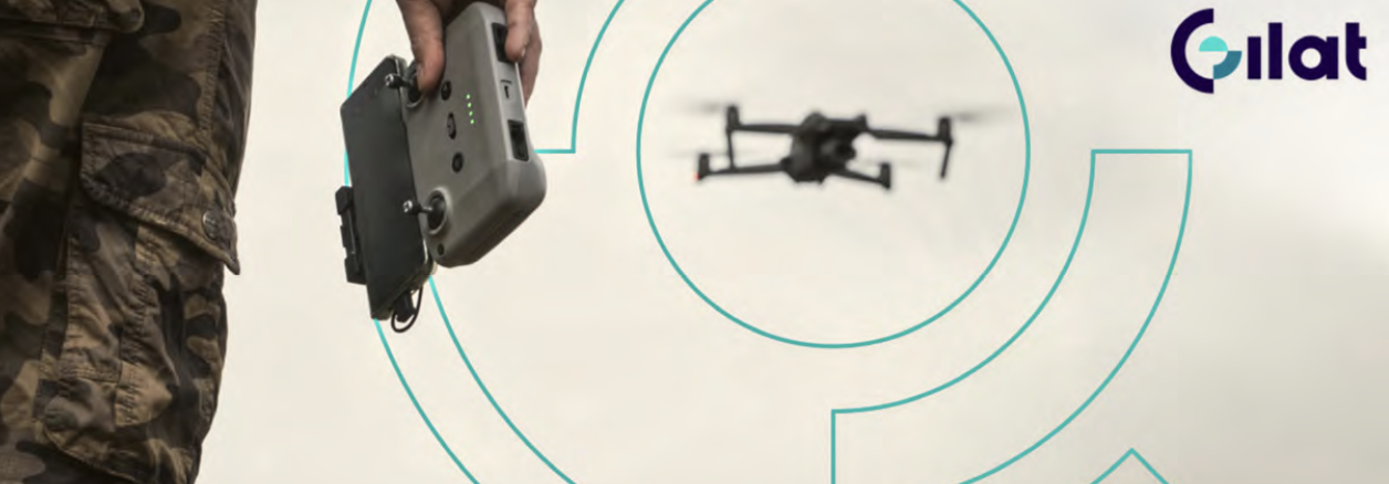
Gilat Satellite Networks Ltd. (NASDAQ: GILT, TASE: GILT) is investing as much as $3.5 million in Crosense, an early-stage startup revolutionizing drone detection and tracking.
The investment is part of a funding round co-led by Frontier Capital, reinforcing strong industry confidence in Crosense’s disruptive technology.
This move aligns with Gilat’s recently declared strategic focus on expanding its presence in the Homeland Security (HLS) and Defense sectors.
Crosense is developing a disruptive new class of deep-tech, electronically steered antenna (ESA) based drone detection and tracking systems, addressing an urgent, unmet need for securing airports, military bases, and critical infrastructure against unauthorized drone activity.
Unlike traditional solutions, Crosense’s passive, all-weather, real-time system will provide 24/7 hermetic coverage, ensuring accurate, scalable, and cost- effective detection in all terrains, including dense urban environments.
“The rapid rise of drone threats has created an immediate demand for more effective detection solutions, and Crosense’s technology is poised to disrupt the market,” said Roni Stoleru, Chief Corporate Development Officer at Gilat. “This investment reflects Gilat’s commitment to the defense sector and our strategy to bring innovative, field-proven solutions to military and government customers worldwide. By supporting Crosense, we are reinforcing our role in safeguarding critical assets with next-generation technologies.”
“We are thrilled to have Gilat as our strategic partner and investor,” said Crosense founder and CEO, Gil Zwirn. “Gilat’s extensive knowledge and expertise, as well as its robust global marketing and sales channels will be instrumental in our journey. This collaboration is expected to propel Crosense forward, fostering innovation and growth, and amplifying our reach and impact.”
Insitu awarded an IDIQ contract mod for Blackjacks + ScanEagles
Insitu Inc. has been awarded a $102,353,293 modification (P00007) to a previously awarded firm-fixed-price, indefinite- delivery/indefinite-quantity contract (N0001922D0038).

This modification increases the contract ceiling to procure 21 RQ-21A Blackjack air vehicles and 47 ScanEagle air vehicles, as well as associated payloads, turrets, support equipment, spares, tools, and training for both Unmanned Aircraft Systems in support of intelligence, surveillance, and reconnaissance for the Navy, Foreign Military Sales customers and other international business partnership capacity efforts.
Work will be performed in Bingen, Washington (88%), and various locations outside the continental U.S. (12%) and is expected to be completed in June of 2026. No funds will be obligated at the time of award; funds will be obligated on individual orders as they are issued. This modification was not competed. Naval Air Systems Command, Patuxent River, Maryland, is the contracting activity.
Iran unveils tracker with military + civilian applications
The Iranian Sohair 1 tracking system has been unveiled in Tehran and features the ability to connect to Global Navigation Satellite System (GNSS) stations operated by the Iranian Armed Forces Geographical Organization.
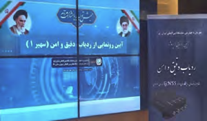
Establishing communication with the permanent GNSS stations of the Armed Forces Geographical Organization to enhance tracking accuracy to the centimeter level is among the capabilities of this system.
Satellite trackers are one of the most important tools of positioning and tracking technology in the modern world, using the Global Positioning System to determine the precise location of objects or individuals. These trackers only connect to the Global Navigation Satellite System (GNSS), and their accuracy is within the meter range.
Currently, the Geographical Organization of Iran has nearly 170 permanent GNSS stations located throughout the country. The tracker, by receiving information from these stations, will be able to provide positioning within the centimeter range, which has applications in various military and civilian fields, including transportation and logistics.
The laboratory prototype of the precise tracker was designed and built at the Geographical Organization of Iran, with its industrial version developed in collaboration with Iranian knowledge-based companies.
Article originally posted by the MEHR News Agency